| ZACA FIRE - Fire Perimeters keep growing - A penny wise and a pound foolish.. Posted: 01 Aug 2007 11:27 AM CDT Santa Barbra CAL FIRE News - The 37,350 acre ZACA Fire Perimeters keep growing and containment has gone down is this fire getting ready to explode? Rumors of a huge 25,000 acre backfire being planned? Is Santa Barbra county in trouble? If weather patterns worsen Santa Barbara could be facing evacuations, structures lost and a horrific firestorm. Could it have been prevented, Did an attempt at cost cutting lead to this situation? This could mean mass evacuation of citizens and large numbers of structures lost costing hundreds of millions of dollars in property loss and thousands of lives disrupted. This fire was being heavily demobilized with cost cutting in mind when she blew out on the late afternoon July 28th growing around 1500 to 2000 acres in just a few hours setting back the containment numbers from 80% to 60% and causing a re-mobilization of resources some of which were being demobilized just hours earlier. Engines, Dozers, Graders, Water tenders, camp kitchens, tents and showers everything that was deemed too expensive now being called back at added expense. The remote access and rugged terrain is requiring a long term strategy that will be implemented over a 5 to 6 week period lets hope the U.S. Forest Service will not be penny wise and a pound foolish.. |
| CA-SCU-westly rest area - VEGETATION FIRE Posted: 31 Jul 2007 09:12 PM CDT CA-SCU-Westly rest area - VEGETATION FIRE Location: Westly rest area and I 5, near 580 transition Sizeup:UTL Orchard nearby burning slash/ debris
Full response on pre-alert, 1666, 1664, 1684, TD's 1741, 1642
Air assests:Helo 106, Tanker 81, 80, 500 Update: continue in code 2 , cancel aircraft |
| Press Release - CAL FIRE Law Enforcement Deploys Laser Scanning to Support Fire Investigations Posted: 31 Jul 2007 07:17 PM CDT Americas - Press Releases:CAL FIRE Law Enforcement Deploys Leica Geosystems' 3D Laser Scanning to Support Fire Investigations and Recovery of Fire Suppression Costs 30 July 2007  ( Norcross, Ga., 31 July 2007) – The California Department of Forestry and Fire Protection (CAL FIRE) has selected the Leica ScanStation 3D laser scanner from Leica Geosystems to support fire investigations on its over 31 million acres of responsibility. Developed for versatility and productivity, the Leica ScanStation provides investigators with a powerful tool for fire scene reconstruction by enabling the rapid collection of millions of high accuracy measurements at the scene. The 3D scan data can then be used to analyze the pre-fire spatial relationships and geometry between trees, branches, terrain, structures and nearby utilities. The ScanStation is a highly mobile laser scanner platform that is uniquely suited to the speed, accuracy and mobility requirements of a fire services organization. CAL FIRE's first introduction to the benefits of 3D laser scanning emerged in the aftermath of a fire several years ago that started when a dead tree fell on a power line. When questions arose as to how the fire started, CAL FIRE called in a local laser scanning consultant to map the area. Using data from a Leica Geosystems laser scanner, the agency was able to show that due to insufficient forest maintenance in the vicinity of power lines, a utility company was responsible for the subsequent fire. The detailed fire scene reconstruction enabled by the Leica Geosystems laser scanner was instrumental in helping CAL FIRE recover over $10 million in fire suppression costs. Since this first application, CAL FIRE has used laser scanning technology to investigate a number of fire scenes throughout the state of California. Tom Hoffman, Chief of Law Enforcement for CAL FIRE says, "We're very excited about having this tool readily available to our investigators and law enforcement personnel. Our goal is to find the truth by determining a reliable and accurate representation of the actual events. Laser scanning can help us do that. Ideally suited to fire investigation, it's quick, very mobile, highly accurate, and most important, provides clarity of evidence in a visually friendly way." Once the 3D scan data is collected, fire investigators can virtually revisit the scene at any time to make additional measurements as the scope of their investigation changes. The digital data can also be imported into CAD or specialized software to create a physical model, rendering or even virtual animations. Tony Grissim, Public Safety and Forensic Account Manager for Leica Geosystems, summarizes, "Fire scene reconstruction is a growing application area for our scanners as both attorneys and insurance companies come to realize the compelling nature of scan data collected by fire investigators. The findings from investigations like these can mean the difference between millions of dollars in pay outs or, in some cases, people going to prison. |
| CAL FIRE Direct attack Posted: 31 Jul 2007 07:06 PM CDT
Great Flickr Photo stream from LUCAS 9-11 Bay Area California Firefighter - Fire Photographer also check out his website : lucas911.com
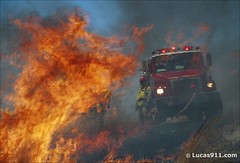 |
| News : California Firefighters Save Wheelchair-Bound Woman from Fire Posted: 31 Jul 2007 05:15 PM CDT Modesto Bee News: Modesto Fire Capt. Matt Curless and firefighter Ryan Viss are trained to wait for a second team of firefighters to arrive before they charge into a burning building. The backup team is supposed to be on the scene just in case Curless and Viss are trapped and need help to get out. But they can disregard that safety rule when they are told someone's life is in danger, Curless said. That's what happened Wednesday afternoon at 2429 Roble Ave., just east of El Vista Avenue in east Modesto. Curless and Viss pulled out wheelchair-bound Joyce Evans, 73, and her son, Wayne Michael Evans, 49, from their burning home. After being told a fourth family member, an adult daughter, was still in the house, the firefighters rushed back against intense flames and thick smoke. After a complete search, and beaten back twice by intense heat, they left the house to find out that the daughter was down the street. "The adrenaline goes up quite a bit, but you rely on your training and you go in," Curless said. Neither firefighter was injured. Family members suffered moderate injuries. Dana Evans, 38, said the fire caught the family off-guard when a fan extension cord ignited a small flame that quickly spread to the wall and the bedsheets in his brother's bedroom in the back of the house. Dana Evans cares for his brother, sister and his mother, who are developmentally handicapped, he said. He was asleep in his bedroom when he heard his mother screaming. He got up to find his brother trying to extinguish the fire with a bucket of water. The flames climbed the walls to the ceiling and nearly trapped the brothers. "It tried to box us in," Dana Evans said. "The fire was behind us now. I just said, 'get out, get out.' " His mom and brother refused to leave immediately, and it was several minutes before he called firefighters. "It's everything they own; they don't want to leave," Dana Evans said. He said his mother weighs about 290 pounds and is confined to a wheelchair. It was stuck and blocking the hallway as the flames continued to spread. In a desperate attempt to get his mother out, Dana Evans pushed her out of the wheelchair and tried to drag her out, but got only as far as the front door. He then ran outside to the back to look for his sister, but he couldn't find her. He returned to the front to meet firefighters, who arrived within three minutes of the call. Viss ran inside to get Joyce Evans, who was crawling to get out. He and Curless pulled her to the lawn and returned to get Wayne Evans, who was trying to put out the flames with a garden hose. He was surrounded by smoke. All Curless and Viss could see was Wayne Evans' two legs below the smoke. "He was really doing more harm to himself than anything else," said Modesto Fire Battalion Chief Sean Slamon. 1,000 DEGREE HEAT When Viss and Curless rushed back in to look for the daughter, heavy flames met them in the hallway. At waist level, the fire reached temperatures of about 1,000 degrees, and the heat in the ceiling was closer to 2,000 degrees, Curless said. The heat pushed back the firefighters twice before other firefighters cut holes in the roof to lift the smoke and relieve the heat. "Frankly, we got our butts kicked a little bit," Curless said. Curless and Viss were able to search all three bedrooms using a thermal-imaging camera. A second team of firefighters conducted a secondary, more thorough, search and did not find anyone. "We were pretty confident nobody was inside," Curless said. Said Dana Evans about his sister's early escape: "Apparently, she was the smart one." The fire collapsed a backyard patio and gutted the home. It caused an estimated $150,000 in damage, Slamon said. Wayne Evans and his mother suffered smoke inhalation and were taken to nearby hospitals. He also suffered burns to his hands and some singed hair. They were released Wednesday night. Red Cross officials provided the family with a temporary place to stay and some clothing. "We have nothing," Dana Evans said. "Everything is burned." To comment, click on the link with this story at www.modbee.com. Bee staff writer Rosalio Ahumada can be reached at rahumada@modbee.com or 578-2394. |
| Wildland Fire Behavior Alert - CAL FIRE Daily Fire Summary Posted: 31 Jul 2007 07:08 PM CDT news: Wildland Fire Behavior Alert **Fire Behavior Alert**
July 31, 2007 THE POTENTIAL FOR EXTREME FIRE BEHAVIOR EXISTS THIS SEASON FOR ALL CAL FIRE UNITS AND CONTRACT COUNTIES The large number of early season shelter deployments and other fire behavior related incidents warrant a review of the conditions that contribute to extreme fire behavior. All of California is experiencing prolonged, record breaking drought and critical fuels conditions. Situational awareness is more than a buzz word – assess the big picture; FUELS-WEATHER-TOPOGRAPHY. Situation factors to consider: • Assess/scout the fire • Always include SAFETY in your actions; making it your number one priority! • Know the Weather • Know Previous & Predicted Fire Behavior • Have the Communications Plan & use it • Look for & understand Local Factors relating to fire behavior Concerns for Firefighters to Consider • Live fuel moisture samples across the state, and especially in Southern California, have been the lowest sampled in history. Critical fuel moisture will be reached at least two months early in most areas. The heat sink properties that live fuel moisture usually provide will be absent this season. Assume live fuels are fully available to burn. Low live fuel moistures and heavier than normal dead fuel accumulations under stressed vegetation will cause explosive fire behavior. • Weather conditions were unusually dry this spring with historically low rainfall and mountain snow pack over the entire state. Soil moisture is exceedingly low and large dead fuels are fully cured. Fuel beds will support rapid ignition, heavy spotting, & high intensity fire spread. • Energy Release Component (ERC) values are above the 90th percentile in all areas, and above the 97th percentile in the most critical areas of the state. The 97th percentile indicates that only 3% of observations have ever been recorded above that level; in other words, the ERC values currently being recorded in most areas of the state are at historical highs. Remember, the ERC calculation is dominated by fuels and does not consider wind or topography and typically trends better than other NFDRS Indices. • Topography plays a significant role in fire intensity through slope, aspect, and channeling. Watch for the daily changes in sun exposure over the various aspects and consider topographic channeling or alignment when evaluating your position. Mitigations Gather intelligence and remember the fundamentals – emphasize and implement LCES prior to engagement! Develop situational awareness of the critical conditions described above. Use your experience or ask the locals what situations cause the greatest difficulty. How's it burning? If your gut makes you anxious, there is probably a good reason! Re-evaluate your situation and act accordingly. Clear and concise communication must be maintained. Evaluate conditions continuously. Monitor fire weather conditions throughout your commitment. Pay attention to how internal and external distractions affect your risk-decisions. Focus on the Big Picture, not the narrow view immediately in front of you. You are empowered to make risk-decisions based on current and expected conditions and your evaluation of probability of success. When considering structure protection, ask yourself, "Is the structure defendable and would you be there if the structure was not?" Do not attempt a frontal assault on a fast moving fire. Existing conditions warrant a "back to the basics" approach to safely mitigate incidents; anchor and flank, one foot in the black, valid safety zones and escape routes. Once you figure all these things out, communicate them to all concerned and make sure someone is acting as a knowledgeable and capable lookout. DO NOT OVER COMMIT! THE FIRST PRIORITY FOR ALL DECISIONS IS FIREFIGHTER SURVIVAL.
CAL FIRE Daily Fire Summary for July 31, 2007
STATE/LOCAL INCIDENTS As of 9 a.m. on July 31 there are no major state or local incidents. CAL FIRE is assisting federal firefighting agencies throughout California. FEDERAL INCIDENTS Zaca Fire15 miles northeast of Buellton Santa Barbara County This fire has burned 33,500 acres and is now 60 percent contained. The Zaca Fire started on July 4 and is burning in steep and rocky terrain. Low humidity and winds resulted in extreme fire behavior yesterday within the Los Padres National Forest wilderness area. Weather conditions are predicted to be relatively the same throughout the week. An evacuation order has been issued for the Community of Peachtree. For the most current evacuation information contact the Zaca Fire Information Center at (805) 961-5770. Over 1,000 firefighters are assigned to this fire. The fire is under a unified command with Santa Barbara County Fire and the US Forest Service. The full containment date is estimated to be September 7. Elk Complex FireNear Happy Camp Siskiyou County This fire has burned 12,656 acres and is 77 percent contained. Of the 30 identified fires in the Elk Complex, 25 are now 100 percent contained. The fires will continue to be monitored, patrolled and staffed as safety, resources and access permit. Over 900 firefighters are assigned to the complex. The complex is expected to be fully contained on August 5.
WEATHER REPORT Northern Region Abundant monsoonal moisture across Nevada will slowly edge westwards towards California today. A weak upper level low off the Central Coast will help shift southwest winds to a more southeast direction by this evening into Wednesday. This should be enough for thunderstorms to form along the Sierra Crest and move further north and northwest into the Northern Sierra area. Isolated thunderstorms, mainly dry are possible this evening near the Tahoe Basin. On Wednesday, a larger scale monsoonal push of moisture will let up with a more widespread thunderstorm threat both wet and dry. Thunderstorm activity could linger into Thursday across the area, but would be mainly wet with locally heavy rain in some spots. Central-Southern RegionA ridge of high pressure centered over the Four Corners Area will maintain near normal temperatures over the region through Friday. A Pacific trough will move over the West Coast bringing cooler temperatures Saturday through early next week. Humidity will be low across most of the region through early next week. Isolated to scattered showers and thunderstorms will continue over the Eastern Deserts through early next week.  Wildland Fire Wildland Fire
|
| InciWeb: Elk Complex Wildland Fire - 13,656 acres - 77% containment. Posted: 31 Jul 2007 01:21 PM CDT Elk Complex Wildland Fire INCIDENT UPDATED 1:10 HRS. AGO ANNOUNCEMENT Elk Complex Community Meeting on Tuesday 07/31/2007
There will be a community meeting regarding the Elk Fire Complex Tuesday July 31, 2007 at 7pm, held at the Happy Camp Grange Hall. Representatives from the fire management team and the local ranger di... more SummaryTotal Complex Acreage: 13,656 acres Total Complex Containment: 77% Expected Full Containment: 8/05/2007 Incident Resources: 987 personnel Cost to Date: $16,100,000 Injuries to Date (minor): 14 Fatalities to Date: 1 Expect an increase in containment as direct strategy and burnout continues. Today, crews will continue burning with the assistance of aerial resources. Crews continue to secure established fireline. Patrol and mop up the Little Grider Fire will continue. There will be a community meeting at the Happy Camp Grange on Tuesday July 31, 2007 at 7:00 p.m. Presentations include updates from the Happy Camp District Ranger and the Elk Complex Incident Commander. Complex Fire Details Of the thirty identified fires in the Elk Complex, 25 are 100% contained. The contained fires will continue to be monitored, patrolled and staffed as safety, resources and access permit. The remaining five fires are as follows: - Wingate/Titus/King Creek 2 Fires (8,420 acres) 36% contained. Firelines have been constructed and burnouts continue. A recommended evacuation for homeowners and closure for campers and miners, from Five Mile Bridge to Norcross Campground on Elk Creek Road remains in place.
- Elk Fire (1,144 acres) 96% contained.
- Hummingbird Fire (80 acres) 0% contained. The fire remains in aerial patrol.
Sources of info include: http://www.inciweb.org/ (including other fires) or the incident information office at (530) 841-4451. Visit http://www.fs.fed.us/r5/klamath/condition/ for information on fire restrictions and local closures. The Siskiyou County Air Pollution Control District has installed an air quality monitoring station in Happy Camp. Real-time data may be viewed online at http://www.satguard.com/usfs/Chart_new.asp?Get=4&UnitID=36&CustID=2&sDate=7/29/2007. # Basic Information | Incident Type | Wildland Fire | | Cause | Lightning | | Date of Origin | 07/10/2007 at 00 hrs. | | Location | Happy Camp Ranger District | | Incident Commander | Kent Swartzlander | Current Situation | Total Personnel | 987 | | Size | 13,656 acres | | Percent Contained | 77% | | Estimated Containment Date | 08/05/2007 at hrs. | | Fuels Involved | Mature heavy timber overstory with brush understory, large quantities of dead fuels and snags. | | Fire Behavior | Slow moving surface fire with short runs on aligned slopes with isolated torching, creeping and roll-out on steep slopes, during the night. | | Significant Events | Continued to secure line burned on previous days. Patrolled and mop-up. | Outlook | Planned Actions | Assess opportunities to apply interior aerial ignitions on the Western portion of the fire. Evaluate further burn operations on the Wingate/Titus/King Creek 2 fire. Secure the line burned on previous days. | | Projected Movement | 12 hours: Continued spread expected due to further drying of fuels and potential burnout/backfire operations. 24 hours: Potential for re-burn in areas wetted by previous rain event as drying continues. Short range spotting activity could increase fire spread. 48 hours: Potential for re-burn in areas wetted by previous rain event as drying continues. Short range spotting activity could increase fire spread. 72 hours: Potential for re-burn in areas wetted by previous rain event as drying continues. Short range spotting activity could increase fire spread. | | Growth Potential | High | | Terrain Difficulty | Extreme | | Containment Target | Likely to meet objectives based on current weather projections. | | Remarks | Expect an increase in containment as direct strategy and burnout continues. A total of seventy-seven miles of fireline has been constructed to date. This includes twenty-eight miles of dozer line and forty-nine miles of handline and brushed roads. A six mile portion of the Klamath River will be used as a west flank containment line for the Wingate/Titus/KingCreek2 fires. Fire acreage and containment: of the thirty identified fires in the Elk Complex, 25 fires are 100% contained. The remaining fires are as follows: King Creek 2/Wingate/ Titus 8,420 acres-64%(increase in acreage due to burn operations); Elk 1,144 acres-96%; Hummingbird 80 acres-0%. Elk fire and Hummingbird fire is in aerial patrol. An additional $773,000 was added into the cost to reflect mobilization and demobilization of 3329 personnel from 7/14-7/30. | Weather | Current Wind Conditions | 1 mph N | | Current Temperature | 56 degrees | | Current Humidity | 77 % |
|
| InciWeb: Zaca Wildland Fire - 33,500 acres - 60% Posted: 31 Jul 2007 12:57 PM CDT Zaca Wildland Fire INCIDENT UPDATED
ANNOUNCEMENT Evacuation Ordered Issued for the Peachtree Community
An EVACUATION ORDER has been issued for the Peachtree Community. An EVACUATION WARNING has been issued for Happy Canyon Road up to Baseline Avenue. With the current warming and drying trend, active burning continued throughout the night in the uncontained, southeast area of the fire. Approximately 1000 acres burned in a southeast direction since yesterday with areas burning out of the San Rafael Wilderness, including two spot fires. The relative humidity recovery overnight was very minimal, only reaching into the mid twenties. Active burning is predicted to continue today, as single digit relative humidities and temperatures into the mid 90s prevail in the fire area. Columns and drift smoke are likely to be seen throughout the Central Coast. While the fire burns in old and heavy fuel, fire crews and air attack are continuing to work diligently to bring this fire to full containment. SummaryLocation: 15 miles Northeast of Buellton, Santa Barbara County Incident Management Team: Los Padres National Forest Start Date & Report Time: July 4, 2007 at 10:53 AM Acres: 33,350 Acres Percent Containment: 60 percent Estimated Containment: September 7, 2007 Resources: Hand Crews: 28; Dozers: 8; Engines: 32; Air Tankers: 2; Helicopters: 14; Water Tenders: 22; Total Personnel: 1,040; Injuries: 8; Structures Threatened: 14; Fireline-to-Build: 15 miles; Estimated Cost-to-Date: $39,100,000 Current Forest and Road Closures: - Happy Canyon Road is open.
- Figueroa Mountain Road is open.
- Los Padres National Forest Closure information and map are available at http://www.inciweb.org/.
- Los Padres National Forest Officials would like to remind forest visitors to be careful when traveling the Happy Canyon and Figueroa Mountain roads due to the continued use of fire equipment in the area.
Significant Events: An EVACUATION ORDER continues for the Peachtree Community. An EVACUATION WARNING remains in place for Happy Canyon Road north of Baseline Avenue, including ranches and residences between Lake Cachuma and McKinley Ridge. With continuing warm and dry conditions, active burning will continue throughout the day in the southeast and northeast areas of the fire. The fire remains in steep, rocky terrain with poor access. The continued poor accesss makes containment diffcult in the wilderness on the eastern flank. Downhill progression to the south and west established fire in the head of Peachtree Canyon and again threatens private lands and structures. Continued low relative humidity (single digit) and wind aligned with topography resulted in extreme fire behavior yesterday. Predicted weather over the next several days and into the weekend is for similar conditions. While the fire burns in old and heavy fuel, fire crews and air attack are continuing to work diligently to bring this fire to full containment. Current Situation: The Forest is evaluating additional closure areas. Two historic cabins at Santa Cruz and Bluff Camp have been wrapped for fire protection. Safety Message: Travelers using SR-154, please be cautious of firefighting equipment and personnel. In addition, with the re-opening of some areas of the forest, we want to remind forest visitors to watch for heavy equipment and crews working on the rehabilitation efforts. Additional Information: In light of the current weather conditions and fire behavior, smoke from the Zaca Fire may be visible over a wide area with occasional drift smoke as far away as Santa Barbara, Goleta or other areas of the county. Incident Commander: AARON GELOBTER Boise Incident Management Team Basic Information | Incident Type | Wildland Fire | | Cause | Human Caused | | Date of Origin | 07/04/2007 at 1053 hrs. | | Location | 15 miles NE of Buellton | | Incident Commander | Aaron Gelobter | Current Situation | Total Personnel | 1,040 | | Size | 33,350 acres | | Percent Contained | 60% | | Estimated Containment Date | 09/07/2007 at hrs. | | Fuels Involved | Chaparral, 6 foot high and oak woodlands. Fuel moisture levels are extremely low, at levels normally seen in late summer. Division J on the SE side of the fire is burning in a mix of pine and chaparral. | | Fire Behavior | The fire continued steady progression through the night to the east in Divisions J and S pushed by winds and fueled by low humidity. Division T continued to hold on the McKinley fuelbreak at the head of Peachtree Canyon. The fire made significant runs with torching and spotting to the northeast toward Mission Pines Basin. | | Significant Events | The Forest is evaluating the closure of additional areas. The evacuation of Peachtree remains in effect. Historic cabins at Santa Cruz and Bluff Camp were wrapped for fire protection. | Outlook | Planned Actions | Divisions T, J and I are the priorities for the next operational period. Division U completed and will be monitored by air resources. Division T should be completed tonight with crews to hold and secure tomorrow. Division S continues improvemnt of indirect line on the Santa Cruz Jeep Trail. Division J completed line to drainage in section 12 west of Mission Pine Camp. Ability to continue direct line efforts in J will be evaluated. | | Projected Movement | Fire will continue to spread to the south and east with a forward spread of 1.5 to 2.0 miles per day to Mission Pine Ridge with the high probability of significantly increasing in size. | | Growth Potential | Extreme. | | Terrain Difficulty | Extreme. | | Containment Target | The remote access and rugged terrain will require a long term strategy that will be implemented over a 5 to 6 week period. | | Remarks | Not available | Weather | Current Wind Conditions | 4-12 mph NE | | Current Temperature | 72 degrees | | Current Humidity | 12-17 % |
|


