California Fire News - Updates in your mail box
California Fire News - Updates in your mail box |  |
| CA-PNF-Red Clover - Prescribed Burn Rekindle Posted: 18 May 2009 08:42 PM PDT
Incident OverviewA prescribed fire that was in mop-up (clean-up from last week's burn), heated up at the end of the day due to gusty winds. Basic Information
Current Situation
Outlook
Current Weather
| ||||||||||||||||||||||
| CA-LPF- Jesusita fire - Quick Look - 8,733 acres 100% Posted: 18 May 2009 08:31 PM PDT
Incident Overview
Jesusita Fire
The Jesusita Fire which began on May 5, 2009 and burned 8,733 acres, was declared 100% contained today at 6:00 p.m. Resources from local agencies will continue to patrol the area and respond to any reports of smoke in or near the fire. A total of 160 structures were destroyed by the fire, as well as an additional 17 structures which were damaged. The fire is under investigation and authorities are asking that anyone with knowledge of how the fire started, please call 805-686-5074.
----------------------------------------------------------------------------------------------------------------------------------
Jesusita Fire Temporary Closure
In order to provide for public safety and resource protection, the Los Padres National Forest has issued a temporary closure order that restricts public entry onto roads and trails in the Santa Barbara Ranger District that were burned during the Jesusita Fire.
What areas are closed The closure order emcompasses all National Forest System (NFS) lands in the front country above Montecito, Santa Barbara and Goleta where approximately 2,000 acres of NFS lands were burned during the Jesusita Fire. The closure extends from Refugio Road (Forest Road 5N19) on the west to Cold Springs Trail (Forest Trail 26W10) on the east, and from West Camino Cielo (Forest Road 5N19) and East Camino Cielo (Forest Road 5N12) on the north to the Congressional boundary of the Los Padres National Forest on the south. The closure includes all lands owned by the United States and administered by the Los Padres National Forest and bounded by the landmarks described above.
Will the State Highway remain open Yes, State Highway 154 will remain open for use and is not affected by this closure.
What about other roads in the closed area Other roads in the closed area will remain closed until further notice.
Are the trails closed Yes. All trails in the burn area are closed.
Does this closure apply to private lands No. This temporary closure does not apply to private lands. It applies to NFS lands only.
How big is the closed area This temporary closure encompasses approximately 2,000 acres that were burned during the Jesusita Fire.
When did the closure take effect The temporary closure went into effect May 12, 2009.
How long will the areas be closed to the public The NFS lands affected by the fire will remain closed until a determination is made that it is safe to re-open the area to public access.
Where can I get more information on the closure For more information on the closure, contact the Los Padres National Forest Supervisor's office at (805) 968-6640, or go to http://www.fs.fed.us/r5/lospadres on the Internet.
----------------------------------------------------------------------------------------------------------------------------------
Photos of Jesusita Fire - Click on photo to enlarge and see description http://www.inciweb.org/incident/pictures/1640
Maps of Jesusita Fire - Click on map to enlarge and see description http://www.inciweb.org/incident/maps/1640
---------------------------------------------------------------------------------------------------------------------------------
Trail Closures http://www.inciweb.org/incident/article/8524
---------------------------------------------------------------------------------------------------------------------------------
Road Closures http://www.countyofsb.org/pwd/roads/closure.htm
---------------------------------------------------------------------------------------------------------------------------------
Local Assistance Center
The County of Santa Barbara will open a Local Assistance Center in the lobby area of the County Administration Building, 105 E. Anapamu St., Santa Barbara, beginning at 9:00 a.m., Monday, May 18, for people who lost their homes, had homes damaged or who were otherwise impacted by the fire. The Assistance Center will be open 9:00 a.m. to 5:00 p.m., Monday through Friday, until further notice.
---------------------------------------------------------------------------------------------------------------------------------
Recovery Meeting
County Supervisors Salud Carbajal, First District, and Janet Wolf, Second District, will co-host a Recovery Meeting at 6:30 p.m., Monday, May 18, at the County Administration Building, 105 E. Anapamu St., in the Fourth Floor Board Hearing Room. The emphasis of the meeting is for residents who lost homes or who had homes damaged during the fire.
---------------------------------------------------------------------------------------------------------------------------------
Red Cross
Anyone currently in need of assistance should go to the Red Cross Service Center at 2101 State Street or call the American Red Cross, Santa Barbara County Chapter at (805) 687-1331.
---------------------------------------------------------------------------------------------------------------------------------
Key Phone Numbers
---------------------------------------------------------------------------------------------------------------------------------
Internet
Basic Information
Current Situation
Outlook
| ||||||||||||||||||||||
| SAR: AIRCRAFT DOWN - Two small planes five miles south of Long Beach, CA Posted: 18 May 2009 09:43 PM PDT
Update: 1930hrs - Searchers have recovered a portion of landing gear and other debris near the site of a reported midair collision, according to authorities. Long Beach fireboat came upon the landing gear and more debris in the water, "We know from the landing gear that at least one of them was a small plane," said Jackawa Jackson, a spokesman for the Long Beach Fire Department. "We've got seagoing companies including two large fire boats and a Coast Guard vessel searching a fairly large area right now." No confirmation of victims.Update: 1900hrs - Search and rescue teams from the U.S. Coast Guard and the Long Beach Fire Department have deployed Monday afternoon to a mid-air collision of two small planes five miles south of the California city of Long Beach off Catalina Island. Authorities received a report of the collision at 5:45 p.m.. "The collision was reported by the pilot of another aircraft, who told authorities he had seen the crash," the Federal Aviation Administration (FAA) spokesman Ian Gregor said. IC: 1810rs - Long Beach Fire is the incident command with Coast Guard assist. Comms: 151.1600 Online Scanner: | ||||||||||||||||||||||
| CA-LPF- Jesusita fire - 8,733 acres 98% - last update Posted: 18 May 2009 11:28 AM PDT
Jesusita Incident - WildFire -05/18/09- 0900 Hours (9:00 a.m.)
This will be the last update unless there are significant changes to the fire.
| ||||||||||||||||||||||
| SAR: Male down in the south fork Stanislaus River - 1 dead Posted: 18 May 2009 11:10 AM PDT
San Andreas, CA -- CAL Fire has identified 33 year old Scott Hernandez of Santa Clara as the Sunday afternoon drowning victim in the South Fork of the Stanislaus River. CAL Fire received a call at 12:40 that a male individual was down in the south fork of the Stanislaus River off Old Strawberry Rd. near the Forest Service compound. The Tuolumne County Sheriff Office's Search and Rescue Team was called to the scene but to no avail. Hernandez's body was recovered several miles downstream. Hernandez was swimming with several friends when the incident occurred. Article Source: mymotherlode.com - Link | ||||||||||||||||||||||
| 24 hour California Fire Weather outlook Posted: 18 May 2009 10:49 AM PDT
Thunderstorm with dry lightning potential during the next 24 hrs. 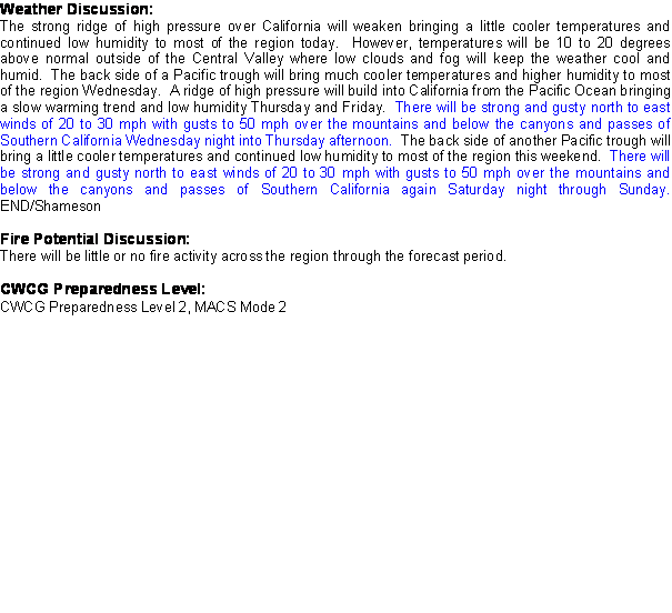 Northern California Geographic Area Preparedness Level 1, MACS Mode 1. Thunderstorm with dry lightning potential during the next 24 hrs. A change in the weather pattern today...with continued hot weather...but as the strong high pressure over us this weekend shifts eastward into the Great Basin, a S to SE upper level flow will bring in some monsoonal moisture and instability. This will all come together to bring Nrn CA its first summertime thunderstorm outbreak of the season later today. Best chances will be along the Sierra...as far north as Susanville. Also a slight chance of thunderstorms along the coastal range as far north as the Bay Area.Most of the storms along the coastal range will be dry...with a mix of dry and wet storms over the Sierra. However, the combination of only moderate fuel dryness along with live fuel moistures should limit any ignitions to small runs...mainly on S to W aspects. For this reason NO high risk days are posted. A cold front drops down from the Pacific NW tonight thru midweek, with clearing, and cooling. However gusty SW to W winds expected across the Eastside and NE CA. Initial attack will likely increase throughout the North Ops region this week...primarily due to thunderstorm potential during the next 24 hrs...as well as SW winds across the Eastside and NE CA late today into Tuesday. Another SW wind episode possible for the Eastside/NE CA late in the week...and this should cause continued drying of fuels and the 1st introduction of Very Dry Fuels to PSA NC08 by the end of the week. Again...lightning strikes today will be primarily dry, but with live fuels should result mainly in ignitions, with small runs on mainly south-west aspects, but little potential of large fires at this time. Source: Northern California Geographic Area - Link | ||||||||||||||||||||||
| Earthquake 3.0 M - The Geysers, Cobb, CA Posted: 18 May 2009 09:08 AM PDT
 Earthquake Details
|
| You are subscribed to email updates from California Fire News - Structure, Wildland, EMS To stop receiving these emails, you may unsubscribe now. | Email delivery powered by Google |
Inbox too full?  Subscribe to the feed version of California Fire News - Structure, Wildland, EMS in a feed reader. Subscribe to the feed version of California Fire News - Structure, Wildland, EMS in a feed reader. | |
| If you prefer to unsubscribe via postal mail, write to: California Fire News - Structure, Wildland, EMS, c/o Google, 20 W Kinzie, Chicago IL USA 60610 | |
