| InciWeb: News Release From Ventura County Fire Protection District Posted: 25 Aug 2007 02:11 AM CDT InciWeb:: News Release From Ventura County Fire Protection District Incident: Zaca
Released: 4 hrs. ago Ventura County Fire Protection District August 24, 2007 Contact Capt Barry Parker (805) 389-9736 CAMARILLO, CA -- The Ventura County Fire Department wants to alert county residents to a fraudulent enterprise in the area soliciting funds allegedly for the benefit of firefighters injured fighting the Zaca Fire. None of the agencies involved in fighting the Zaca Fire - including the Ventura County Fire Department, the U.S. Forest Service or the CalFire - has authorized any fundraising activities. "Speaking for all the firefighters who have been working the Zaca Fire, we're very grateful for the support the public has shown us," said Capt. Barry Parker, information officer for the Ventura County Fire Department, "and we don't want to see our citizens victimized by unscrupulous criminals using a tremendous firefighting effort to defraud them." Any resident receiving a call, leter or e-mail soliciting funds for injured firefighters is urged to call their local police agency or the fire department. |
| ZACA FIRE ALERT ! - RECOMMENDED EVACUATION FOR AN AREA WEST OF HIGHWAY 33, BETWEEN OZENA AND BURGES CANYON ROAD. Posted: 24 Aug 2007 09:50 PM CDT ALERT ! DUE TO A CHANGE IN THE FIRE'S BEHAVIOR ON THE NORTH EAST SIDE, THE VENTURA COUNTY SHERIFF'S DEPARTMENT HAS NOW ORDERED A RECOMMENDED EVACUATION FOR AN AREA WEST OF HIGHWAY 33, BETWEEN OZENA AND BURGES CANYON ROAD. |
| Inciweb: Zaca Wildland Fire - 235,601 acres - 83% Posted: 24 Aug 2007 09:48 PM CDT Zaca Wildland Fire INCIDENT UPDATED 1:28 HRS. AGO SummaryALERT ! DUE TO A CHANGE IN THE FIRE'S BEHAVIOR ON THE NORTH EAST SIDE, THE VENTURA COUNTY SHERIFF'S DEPARTMENT HAS NOW ORDERED A RECOMMENDED EVACUATION FOR AN AREA WEST OF HIGHWAY 33, BETWEEN OZENA AND BURGES CANYON ROAD. ZACA FIRE UPDATE Friday, August 24, 2007 12 o'clock noon Fire Status: Acres Burned: 235,601 acres Acreage Increase (last 12 hours): 3,152 acres Fireline to Build: 7 miles Date Started: July 4, 2007 at 10:53 am Percent Contained: 83 percent Expected Containment: September 7, 2007 Injuries: 40 Structures Threatened: 66 Structures Destroyed: 1 outbuilding Resources: Crews: 66 Engines: 98 Helicopters: 16 Air Tankers: 8 Air Attack: 3 Dozers: 29 Water Tenders: 78 Total Personnel Assigned: 2,545 Cost to Date: $ 99.7 million Headlines: ·· Paradise Road is open from Highway 154 to the First Crossing Day Use Area. ·· Highway 33 from Wheeler Gorge to Quatal Canyon remains closed, except to residents. Fire officials hope to reopen Highway 33 to thru traffic by 6 p.m. on Sunday, August 26, contingent upon fire behavior and fire fighting success. At times, residents from the Ozena area may not be able to access their homes when firing operations next to the highway would result in unsafe driving conditions. Current Situation: Last night crews continued burning along the Brubaker Canyon Road until humidity became too high to successfully burn. Firing operations were completed along the Cuyama River wash for a one quarter mile stretch north of Rancho Nuevo Canyon. Today, crews will continue to build handline along the western perimeter of the fire north and south of the Sisquoc River. Several interior islands of unburned vegetation will continue to burn producing large columns of smoke. These islands do not threaten fireline integrity. Natural resource advisors have begun to assess wildfire suppression rehabilitation needs and will begin rehabilitation work today. A Cobra helicopter with infrared technology will be used today to detect hot spots within the fire area. The Live Oak Zone has reached full containment and efforts continue to be focused on furthering rehabilitation and restoration of those areas affected by the fire and suppression activities. There was significant progress yesterday in rehabilitation efforts. Road closures and evacuations associated with the Live Oak fire suppression activities on the south side have been lifted, however, all areas and roads included within the Los Padres National Forest Closure Area remain closed to public entry. State Highways, Forest Roads and Area Closures: - Hwy 33 between Wheeler Gorge and Quatal Canyon will be closed to all traffic until Sunday, August 26, except for residents. See headline above.
- Happy Canyon Road is closed at the Los Padres National Forest boundary.
- Figueroa Mountain Road is closed at the Los Padres National Forest boundary.
- East Camino Cielo Road is now open between Hwy 154 and Gibraltar Road. East Camino Cielo is still closed east of Gibraltar Road because it is within the Forest closure.
- Paradise Road is open from Highway 154 to First Crossing Day Use Area.
- The Zaca Fire Area Closure in Los Padres National Forest remains in effect. The closure includes lands in Santa Barbara, Ventura, and Kern Counties. The expanded closure encompasses approximately 888,000 acres including the entire San Rafael, Matilija, and Chumash Wildernesses, a portion of the Sespe Wilderness, and adjacent national forest lands. Detailed information on the closure can be found at www.fs.fed.us/r5/lospadres or www.inciweb.org or at a Los Padres National Forest office.
Evacuations: - A PRECAUTIONARY EVACUATION is in effect for residents along the west side of Highway 33 from the Ventura/Santa Barbara County line to Pine Mountain Summit.
- Recreation facilities along Paradise Road between Highway 154 and First Crossing, including Forest Service campgrounds and Rancho Oso Campground, are now open. The Santa Ynez River Road, beyond the First Crossing and all associated recreation facilities are closed.
Basic Information | Incident Type | Wildland Fire | | Cause | Human Caused | | Date of Origin | 07/04/2007 at 1053 hrs. | | Location | 9 miles north of Santa Barbara | | Incident Commander | Oplinger/ Hawkins | Current Situation | Total Personnel | 2,545 | | Size | 235,601 acres | | Percent Contained | 83% | | Estimated Containment Date | 09/07/2007 at hrs. | | Fuels Involved | Heavy brush containing a high dead component. Some conifer at higher elevations. Live fuel moistures are at 49% which is well below critical levels. A continuous fuel bed lies ahead of the fire. | | Fire Behavior | Live Oak Zone: Unburned fuel in the Santa Cruz drainage continued to actively burn back down slope. Richardson Zone: Minimal fire behavior. | | Significant Events | Live Oak Zone: Fire Suppression Rehab continuing. Richardson Zone: Hold and Mop up burnout operations in Division BB, and FF. Continue with firing and holding operations in Division BB and FF if conditions allow. Road closure for Hwy 33. Continue line construction from the Sierra Madre Ridge South into the Sisquoc river this evening. | Outlook | Planned Actions | Live Oak Zone: Patrol and mop-up. Continue Fire Suppression Rehab. Richardson Zone: Div AA and BB direct line construction from Sierra Madre Ridge south in to the Sisquoc River. Continue firing in Div FF east to Hwy 33 and from Ozena north towards Brubaker Rd. Fixed wing air support on Div FF South. Hold and patrol Div CC, DD and HH. A precautionary evacuation continues west of Hwy 33 from the Santa Barbara/Ventura Co. line south to Pine Mountain Inn and is being coordinated by Ventura County Sheriffs, assisted by Santa Barbara Sheriffs. Hwy 33 remains closed. | | Projected Movement | Richardson Zone: West and North down Sisquoc River toward Sierra Madre Ridge. North to Dry Canyon, East to Hwy 33. | | Growth Potential | Extreme. | | Terrain Difficulty | Extreme. | | Containment Target | Live Oak Zone: The Management strategy has succeeded. Richardson Zone: High on ability to anchor and hold on Sierra Madre Ridge toward Hwy 33 and moderate from Pine Mtn. summit toward Ozena. Moderate on West perimeter. | | Remarks | Richardson Zone: Block 16: Total zone mileage calculated at 62.5 miles. Contained zone mileage = 36.7 miles or 59%. A Precautionary Evacuation Order is in place for the area west of Hwy 33 from the Santa Barbara/Ventura Co. line south to Pine Mountain Inn. Road Closure in effect on Hwy 33; Closed to all traffic from Pine Mountain Summit to Ozena. | Weather | Current Wind Conditions | 4 (g8) mph NE | | Current Temperature | 64 degrees | | Current Humidity | 47 % |
|
| NASA Predator drone is flying missions on California fires Posted: 24 Aug 2007 02:20 PM CDT Drones Spot Fires NASA calls their version of the aircraft "Ikhana," a name derived from a Native American Choctaw word that means intelligent, conscious or aware. Dryden Research completed a six-month process to obtain a Certificate of Authorization from the FAA allowing Ikhana to fly wildfire-sensing missions in the national air space of the western states.  A NASA Predator B drone is flying missions over Californian wild fires to test out new gear for spotting fires, the agency reports. A NASA Predator B drone is flying missions over Californian wild fires to test out new gear for spotting fires, the agency reports.
Press release The first flight of the series Aug. 16 captured images of California wildfires, including the Zaca Fire in Santa Barbara County. The aircraft carried instruments that collected data while flying more than 1,200 miles during a 10-hour period.
"These tests are a ground-breaking effort to expand the use of unmanned aircraft systems in providing real-time images in an actual fire event," said Vincent Ambrosia, principal investigator of the Western States Fire Mission at NASA Ames Research Center, Moffett Field, Calif. "This is a prime example of NASA science and technology being used to solve real-world problems."
 "The images from the flight demonstrated that this technology has a future in helping us fight wild land fires," stated Zaca Incident Commander Mike Dietrich. "We could see little on the ground since the fire was generating a lot of smoke and burning in a very remote and inaccessible area. This technology captured images through the smoke and provided real time information on what the fire was doing," said Dietrich. "The images from the flight demonstrated that this technology has a future in helping us fight wild land fires," stated Zaca Incident Commander Mike Dietrich. "We could see little on the ground since the fire was generating a lot of smoke and burning in a very remote and inaccessible area. This technology captured images through the smoke and provided real time information on what the fire was doing," said Dietrich. Pilots from NASA and Ikhana manufacturer General Atomics Aeronautical Systems, Inc. operate the aircraft from a ground control station at Dryden, located at Edwards Air Force Base, Calif. NASA sponsorship is provided by the agency's Science Mission Directorate, Washington, D.C. The aircraft is a scientifically focused version of the already-proven Predator technology, complete with a sensor that can detect temperature differences from less than one-half degree to about 1,000 degrees Fahrenheit. Detailed thermal imagery of wildfires can be sent real-time anywhere in the world through a satellite data link. For photos and illustrations supporting the wildfire imaging mission, visit: http://www.nasa.gov/centers/dryden/news/newsphotos/index.html For more information about NASA and agency programs, visit: http://www.nasa.gov/home > 
|
| CA-SCU-CUMMINGS INCIDENT - Wildland Fire Posted: 24 Aug 2007 02:25 PM CDT Location: West side of I-80 and east of Cummings Skyway
Sizeup: 5 - 10 acres Full CAL FIRE- wildland response, COCO county fire, LNU engines 1466, Marin, Tankers 86, 85, Helicopters: CHP H-30, Eagle- 5, 106,105, 3 Dozers 1540, 1642, 1741 Crews ordered - Delta 6 aiu, 1555 1663, 1665, 1676, 1683, 1685, 1686 Comms: Cummings IC-BC 1614 COM: 151.445 Tone 2 TAC: CDF Tac-2 Updates
11:38: Cummings air attack 5 -10 acres burning parallel to highway.
12:00: 80% Contained, cancel Crews and Dozer's.
1205: Delta 6 Crew recommitted at scene
1209: Tankers 85, 86 released1213: Air Attack -104 released leaving unit for Sonoma Incident - LNU |
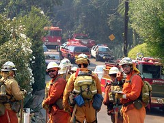
| Preparing For the Ground Assault - Skyline fire Posted: 24 Aug 2007 01:32 PM CDT - The Camp Crew grunts -
Skyline fire - Great pictures from a CAL FIRE News reader
Preparing For the Ground Assault
12 of13
Credit: by Bodie Bailey |
| Inciweb: Snow Wildland Fire - 100 acres - 75% Posted: 24 Aug 2007 12:27 PM CDT Snow Wildland Fire INCIDENT UPDATED 1:15 HRS. AGO SummaryThe Snow Fire began at approximately noon on Aug. 21, 2007 and is burning in heavy brush and timber. The fire began in the San Jacinto Mountains in the Black Mountain Scenic Area northeast of Black Mountain Group Campground. Access to portions of the fire is difficult. Six abandoned structures at Camp Lackey have been burned, but no communities are threatened. The cause of the fire is lightning. Full containment is expected on August 27, with full control expected by September 2. Basic Information | Incident Type | Wildland Fire | | Cause | Lightning | | Date of Origin | 08/21/2007 at 1157 hrs. | | Location | NE OF THE TOWN OF PINE COVE | | Incident Commander | Dave Fiorella | Current Situation | Total Personnel | 474 | | Size | 100 acres | | Percent Contained | 75% | | Estimated Containment Date | 08/27/2007 at hrs. | | Fuels Involved | Heavy brush and timber. | | Fire Behavior | Smoldering with single tree torching. | | Significant Events | Six abandoned structures at Camp Lackey have been burned, but no communities are threatened. Mandatory evacuation of Black Mtn, Boulder Basin Campgrounds, the portion of the San Jacinto State Park Wilderness and the Pacific Crest Trail in the immediate fire area, remain in effect. | Outlook | Planned Actions | Continue direct line construction and mop up where possible. Utilize aircraft to support ground operations. | | Projected Movement | None, if current conditions continue. | | Growth Potential | Medium. | | Terrain Difficulty | High | | Containment Target | The chosen strategy should succeed on 8/27. | | Remarks | 19 crews, 3 helicopters, 17 engines, 1 dozer and 10 water tenders are on scene. | Weather | Current Wind Conditions | 5 Gusts 14 mph W | | Current Temperature | 58 degrees | | Current Humidity | 36 % |
|
| Inciweb: Zaca Wildland Fire - 235,601 acres - 83% Posted: 24 Aug 2007 12:21 PM CDT Zaca Wildland Fire INCIDENT UPDATED 27 MIN. AGO SummaryZACA FIRE UPDATE Friday, August 24, 2007 9:00 AM Fire Status: Acres Burned: 235,601 acres Acreage Increase (last 12 hours): 3,152 acres Fireline to Build: 7 miles Date Started: July 4, 2007 at 10:53 am Percent Contained: 83 percent Expected Containment: September 7, 2007 Injuries: 40 Structures Threatened: 66 Structures Destroyed: 1 outbuilding Resources: Crews: 66 Engines: 98 Helicopters: 16 Air Tankers: 8 Air Attack: 3 Dozers: 29 Water Tenders: 78 Total Personnel Assigned: 2,545 Cost to Date: $ 99.7 million Headlines: ·· Paradise Road is open from Highway 154 to the First Crossing Day Use Area. ·· Highway 33 from Quatal Canyon to Ozena remains closed, except to residents. Fire officials hope to reopen Highway 33 to thru traffic by 6 p.m. on Sunday, August 26, contingent upon fire behavior and fire fighting success. Current Situation: Last night crews continued burning along the Brubaker Canyon Road until humidity became too high to successfully burn. Firing operations were completed along the Cuyama River Wash for a one quarter mile stretch north of Rancho Nuevo Canyon. Today, crews will continue to build handline along the western perimeter of the fire north and south of the Sisquoc River. Several interior islands of unburned vegetation will continue to burn producing large columns of smoke. These islands do not threaten fireline integrity. Natural Resource advisors have begun to assess wildfire suppression rehabilitation needs and will begin rehabilitation work today. A Cobra helicopter with infra red technology will be used today to detect hot spots within the fire area. There was significant progress in rehabilitation efforts in the Live Oak Zone of the Zaca Fire. The Live Oak Zone has reached full containment and efforts continue to be focused on furthering rehabilitation and restoration of those areas affected by the fire and suppression activities. Road closures and evacuations associated with fire suppression activities have been lifted, however, all areas and roads included within the Los Padres National Forest Closure Area remain closed to public entry. State Highways, Forest Roads and Area Closures: - Hwy 33 between Quatal Canyon to Ozena will be closed to all traffic until Sunday, August 26, except for residents.
- Happy Canyon Road is closed at the Los Padres National Forest boundary.
- Figueroa Mountain Road is closed at the Los Padres National Forest boundary.
- East Camino Cielo Road is now open between Hwy 154 and Gibraltar Road. East Camino Cielo is still closed east of Gibraltar Road because it is within the Forest closure.
- Paradise Road is open from Highway 154 to First Crossing Day Use Area.
- The Zaca Fire Area Closure in Los Padres National Forest remains in effect. The closure includes lands in Santa Barbara, Ventura, and Kern Counties. The expanded closure encompasses approximately 888,000 acres including the entire San Rafael, Matilija, and Chumash Wildernesses, a portion of the Sespe Wilderness, and adjacent national forest lands. Detailed information on the closure can be found at www.fs.fed.us/r5/lospadres or www.inciweb.org or at a Los Padres National Forest office.
Evacuations: - A PRECAUTIONARY EVACUATION is in effect for residents along the west side of Highway 33 from the Ventura/Santa Barbara County line to Pine Mountain Summit.
- Recreation facilities along Paradise Road between Highway 154 and First Crossing, including Forest Service campgrounds and Rancho Oso Campground, are now open. The Santa Ynez River Road, beyond the First Crossing and all associated recreation facilities are closed.
Basic Information | Incident Type | Wildland Fire | | Cause | Human Caused | | Date of Origin | 07/04/2007 at 1053 hrs. | | Location | 9 miles north of Santa Barbara | | Incident Commander | Oplinger/ Hawkins | Current Situation | Total Personnel | 2,545 | | Size | 235,601 acres | | Percent Contained | 83% | | Estimated Containment Date | 09/07/2007 at hrs. | | Fuels Involved | Heavy brush containing a high dead component. Some conifer at higher elevations. Live fuel moistures are at 49% which is well below critical levels. A continuous fuel bed lies ahead of the fire. | | Fire Behavior | Live Oak Zone: Unburned fuel in the Santa Cruz drainage continued to actively burn back down slope. Richardson Zone: Minimal fire behavior. | | Significant Events | Live Oak Zone: Fire Suppression Rehab continuing. Richardson Zone: Hold and Mop up burnout operations in Division BB, and FF. Continue with firing and holding operations in Division BB and FF if conditions allow. Road closure for Hwy 33. Continue line construction from the Sierra Madre Ridge South into the Sisquoc river this evening. | Outlook | Planned Actions | Live Oak Zone: Patrol and mop-up. Continue Fire Suppression Rehab. Richardson Zone: Div AA and BB direct line construction from Sierra Madre Ridge south in to the Sisquoc River. Continue firing in Div FF east to Hwy 33 and from Ozena north towards Brubaker Rd. Fixed wing air support on Div FF South. Hold and patrol Div CC, DD and HH. A precautionary evacuation continues west of Hwy 33 from the Santa Barbara/Ventura Co. line south to Pine Mountain Inn and is being coordinated by Ventura County Sheriffs, assisted by Santa Barbara Sheriffs. Hwy 33 remains closed. | | Projected Movement | Richardson Zone: West and North down Sisquoc River toward Sierra Madre Ridge. North to Dry Canyon, East to Hwy 33. | | Growth Potential | Extreme. | | Terrain Difficulty | Extreme. | | Containment Target | Live Oak Zone: The Management strategy has succeeded. Richardson Zone: High on ability to anchor and hold on Sierra Madre Ridge toward Hwy 33 and moderate from Pine Mtn. summit toward Ozena. Moderate on West perimeter. | | Remarks | Richardson Zone: Block 16: Total zone mileage calculated at 62.5 miles. Contained zone mileage = 36.7 miles or 59%. A Precautionary Evacuation Order is in place for the area west of Hwy 33 from the Santa Barbara/Ventura Co. line south to Pine Mountain Inn. Road Closure in effect on Hwy 33; Closed to all traffic from Pine Mountain Summit to Ozena. | Weather | Current Wind Conditions | 4 (g8) mph NE | | Current Temperature | 64 degrees | | Current Humidity | 47 % |
|