Tuesday, August 7, 2007

California Fire News

California Fire News

Inciweb update: Zaca Wildland Fire - 67,675 acres acres - 68 percent

Posted: 06 Aug 2007 08:43 PM CDT

ZACA FIRE / ZACA FIRE 2 -
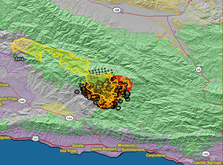
Map; of current fires - Perimeters
Credit: Zaca Fire GIS Section


Zaca Wildland Fire

INCIDENT UPDATED 6 HRS. AGO


Credit: Zaca Fire GIS Section

view pictures || view maps

Summary

Morning Update Monday August 6, 2007

Location: 15 miles northeast of Buellton, Santa Barbara County

Joint Unified Incident Management Teams: Los Padres National Forest and Santa Barbara County Fire Dept

Start Date & Report Time: July 4, 2007 at 10:53 AM

Acres: 67, 675 Acres

Percent Containment: 68 percent

Estimated Containment September 7, 2007

Resources: Hand Crews: 68; Dozers: 14; Engines: 111; Water Tenders: 28; Helicopters: 7-Type 1, 6-Type 2 and 4-Type 3; Air Tankers: 8; Air Attact:2; Total Personnel: 2,345; Injuries: 13; Structures Threatened: 515; Fireline-to-build: 44 miles; Estimated Cost-to-date: $52 million

Significant Events: An EVACUATION ORDER for Paradise Road and Lower Santa Ynez River Road to Gibraltar Dam remains in effect. The Evacuation Order includes the Paradise Road Community, Santa Ynez Road Recreational Areas to Gibraltar Dam, Los Prietos Boys Camp, and the Rancho Oso Guest Ranch. An EVACUATION ORDER continues for the Peachtree Community. An EVACUATION WARNING remains in place for Happy Canyon Road north of Baseline Road, including the ranches between Lake Cachuma and McKinley Ridge. The Los Padres National Forest expanded closure is in effect. The closure area is approximately 649,000 acres and is between Hwy 166 in northern Santa Barbara County and Highway 33 and Matilija Canyon in Ventura County.

Current Situation:

The inversion layer diminished fire activity last night. The fire has reached the Dick Smith Wilderness. Fire line on the north continues to hold along the Mission Pine Trail with the support of air tankers and hand crews. Due to the fires location, the Richardson camp will be set up in New Cuyama to run the north section of the fire and the Live Oak Camp will remain to run the south section of the fire. A section of Highway 154 remains closed. Smoke columns were visible through the Central Coast and the San Joaquin Valley. The fire line at the head of Peachtree Canyon continues to hold. Dozers continue to construct line along Camuesa Road. Structure protection groups remain in place in the Peachtree and Paradise areas and continue working on improvements arount structures. Engine companies and handcrews are currently working in the communities of Camino Cielo today to familarize themselves with the area.

A Cal-Fire base camp has been established at the Earl Warren Show Grounds. It will be the base camp for the "Front Country Support Group" for personnel and equipment that are currently preplanning the Santa Ynez Ridge communities and cities on the south coast. This group will support current fire fighting resources that would be providing structure protection, if the fire should threaten the above areas.

Current Forest and Road Closures:

  • Happy Canyon Road is closed at Los Padres National Forest boundary.
  • Figueroa Mountain Road is closed at the Los Padres National Forest boundary.
  • East Camino Cielo is closed between Painted Cave Road and Gibraltar Road due to fire equipment traffic.
  • Paradise Road is within the Evacuation Order Area and is currently closed.
  • Hwy 154 is closed to general traffic between Foothill Road and Hwy 246. After Highway 154 reopens, travelers driving on San Marcos Pass (Hwy 154) should tune to 1040 AM.
  • Los Padres National Forest closure information and map are available at http://www.inciweb.org/.

Safety Message: Travelers using SR-154, please be cautious of firefighting equipment and personnel. Gibraltar Road, Painted Cave Road and East Camino Cielo residents are also asked to be cautious of firefighting equipment and personnel.

Unified Incident Commanders:
Bill Molumby Incident Command Team 2 and Mark Schmitt, Santa Barbara County Fire Dept

Basic Information

Incident Type Wildland Fire
Cause Human Caused
Date of Origin 07/04/2007 at 1053 hrs.
Location 15 miles NE of Buellton
Incident Commander Bill Molumby/ Mark Schmit

Current Situation

Total Personnel 2,345
Size 67,675 acres
Percent Contained 68%
Estimated Containment Date 09/07/2007 at hrs.
Fuels Involved

Vegetation is oak/conifer woodland which contains a large amount of dead component. A continuous fuelbed lies ahead of the dominant spread direction of the fire.

Fire Behavior

Overnight fire activity diminished somewhat during the nighttime hours as an inversion layer set-in.

Significant Events

A Type 1 team has transitioned with the teams that have been managing the fire and is now in place.

Outlook

Planned Actions

Direct construction will continue where possible in all Divisions where there active fire. Strengthing and holdin lines will continue in the south and west sides of the active fire. Dozer groups continue cleanup of existing fuelbreaks in preparation for burn out activities and holding operations, when they are necessary. Dozer work continues on contingency lines along Camuesa Road. Southwest winds will favor control efforts along western and southern flanks while these winds will increase difficulty of fighting the fire in the northern and eastern flanks.

Projected Movement

Southwest winds will continue to push the fire in northerly and easterly directions.

Growth Potential

Extreme.

Terrain Difficulty

Extreme.

Containment Target

The lack of access and rugged terrain require a long term strategy of both direct and indirect attack with contingency planning that is being implemented over a 5 to 6 week period.

Remarks

Not available

Weather

Current Wind Conditions 11-18 mph SW
Current Temperature mid 70 degrees
Current Humidity 12 %


GIS Pictures of ZACA Fire - Geographical maps

Posted: 06 Aug 2007 08:10 PM CDT

Reader supplied GIS Photos of the ZACA Fire
The geographical representations of the ZACA Fire,
images created using gis software
ZACA Fire - looking south east, lower elevation
ZACA Fire - 40,000 feet, looking north

See the whole set and much larger versions at HUMAN RACE .ORG
http://www.humanrace.org/fire/zaca1.htm

[EDIS] at risk missing elderly male

Posted: 06 Aug 2007 06:55 PM CDT

NCIC as an Missing Person Endangered
At risk missing elderly male
The Thousand Oaks Police Department and Ventura County Sheriff`s Department are investigating the disappearance of 84-year-old Kenneth Weaver.

Kenneth attended a play in Simi Valley California on 8-5-07. He placed a cellular phone call to his family at approximately 2 am the following morning (8-6-07) stating that he was lost, possibly in the area of Los Robles Hospital in Thousand Oaks.He has not been heard from since.
Weaver is described as a Caucasian male, 5-5, 170 pounds, white hair, blue eyes and his date of birth is July 11, 1923.He was last seen wearing a gray suit with a blue shirt and is driving a gray 2002 Ford Focus, license# 4XOR733.Weaver is listed in NCIC as an "Missing Person Endangered."
We are requesting assistance from the public and law enforcement agencies in locating Kenneth Weaver.If located, please contact the Ventura County Sheriff`s Department at (805) 654-9511.

Instruction:
Attempt to locate.

Area: Ventura

Affected Counties or parts of: Santa Barbara, Ventura, Los Angeles,

Sent: 2007-08-06T14:50:05-07:00

From: Ventura Co Sheriffs OES

News: Tractor-trailer plunges off overpass in Paso

Posted: 06 Aug 2007 04:14 PM CDT

SanLuisObispo.com - Tractor-trailer plunges off overpass in Paso Robles:

Paso Robles

A tractor-trailer hauling produce plunged about 100 feet off an overpass in Paso Robles, landing on an on-ramp and trapping the driver and a passenger inside the cab.

Rescuers arrived at the North Spring Street on-ramp shortly after 2 a.m. Sunday and found two people, including a 4-year-old boy, stuck in the cab.

The driver, 52-year-old Alejandro Perez of Watsonville, was driving south on Highway 101 about 55 mph just north of the North Spring Street overpass when his truck drifted to the right and hit a guardrail, according to the CHP.

His truck drove up a concrete bridge before rolling over, falling 50 feet and landing on its roof near North Spring Street.

Firefighters pulled both passengers from the cab in less than 20 minutes using hydraulic power tools.

San Luis Ambulance paramedics then took the two to Twin Cities Community Hospital in Templeton, where they were treated for moderate injuries.

The 4-year-old was not wearing a seat belt, according to the CHP, which is investigating the wreck's cause.

El Dorado County Sheriff’ - Press Release - Airplane Crash

Posted: 06 Aug 2007 12:56 PM CDT

Update:
Airplane crash just south of the City of South Lake Tahoe
Airport.

August 5, 2007
On August 5, 2007, at about 9:45 a.m., El Dorado County Sheriff's Office personnel
responded to a report of an airplane crash just south of the City of South Lake Tahoe
Airport.
Responding law enforcement and Fire/Rescue units located the site just south
of Elks Club Drive near Waverley Drive. This area is a moderately developed residential
sub-division and the impact was into an undeveloped forested lot.
The wreckage was of a single engine Piper aircraft. Two persons were found at the site.
One was pronounced dead at the scene, the other was evacuated by helicopter to a
trauma unit in Reno, NV. No other persons are believed to have occupied the airplane
at the time of the crash. The survivor's condition is unknown at the time of this release.
The identity of the decedent will not be released until next of kin has been notified.
The National Transportation Safety Board has been notified and will, in conjunction with
the El Dorado County Sheriff's Coroner's Unit, conduct an investigation into the cause of
the incident. At this time, it is unclear if mechanical problems or this morning's
significant high winds contributed to the event.

Update: August 6, 2007

  • The individuals involved in the airplane crash have been identified as
    pilot (deceased) Robert Neil Rollins, 36 years of age, out of Concord,
    CA.
  • The survivor, Rachel Ann Belo, 26 years of age, out of
    Brentwood, CA was airlifted to Renown Hospital at Reno, NV in
    critical condition.

An autopsy is scheduled for today for decedent Rollins and the
investigation into the cause of the crash continues.
Respectfully,
_______________________
Lt. Les Lovell, L84
El Dorado County Sheriff's Office
Lake Tahoe Station
(530) 573-3026

Breaking News OT- Utah: Six miners trapped in Coal mine after earthquake

Posted: 06 Aug 2007 11:41 AM CDT

Earthquake Traps 6 Miners In Central Utah
"Rescue workers are on scene trying to locate six miners that are unaccounted for," the Emery County sheriff's office said. The earthquake occurred at 2:48 a.m, The Genwal mine reported a "cave-in" at 3:50 a.m., an hour after the earthquake


A coal mine collapsed Monday in central Utah, trapping six miners, less than 20
miles from the epicenter of a 4.0 magnitude earthquake.
Rocky Mountain Power, a utility with a power plant in the area, sent a rescue team and heavy equipment to the mine, about 140 miles south of Salt Lake City, spokesman Dave Eskelsen said.
A command center was being set up in Huntington, about 15 miles from the mine, said Teresa Behunin, an accountant with Utah American Energy, which owns the mine.


Event:Earthquake

Headline:EQ 4.0 Mount Pleasant, UT - PRELIMINARY REPORT

Description:An earthquake with magnitude 4.0 occurred near Mount Pleasant, UT at 08:48:40.60 UTC on Aug 6, 2007. (This event has been reviewed by a seismologist.)

Web:http://earthquake.usgs.gov/eqcenter/recenteqsus/Quakes/uu00007535.php

Inciweb update: Zaca Wildland Fire - 63,350 acres - 68 percent

Posted: 06 Aug 2007 11:21 AM CDT

Zaca Wildland Fire

INCIDENT UPDATED 12 HRS. AGO
map: zaca fire map of perimeter

Zaca Fire Perimeter Map
Credit: Zaca Fire GIS Unit

view pictures || view maps

Summary

Evening Update Sunday August 5, 2007

Location: 15 miles northeast of Buellton, Santa Barbara County

Joint Unified Incident Management Teams: Los Padres National Forest and Santa Barbara County Fire Dept

Start Date & Report Time: July 4, 2007 at 10:53 AM

Acres: 63,350 Acres

Percent Containment: 68 percent

Estimated Containment September 7, 2007

Resources: Hand Crews: 68; Dozers: 17; Engines: 111; Water Tenders: 28; Helicopters: 7-Type 1, 6-Type 2 and 4-Type 3; Air Tankers: 8; Air Attack: 2; Total Personnel: 2,294; Injuries: 13; Structures Threatened: 515; Fireline-to-Build: 44 miles; Estimated Cost-to-Date: $50.3 million

Significant Events: An EVACUATION ORDER for Paradise Road and Lower Santa Ynez River Road to Gibraltar Dam remains in effect. The Evacuation Order includes the Paradise Road Community, Santa Ynez Road Recreational Areas to Gibraltar Dam, Los Prietos Boys Camp, and the Rancho Oso Guest Ranch. An EVACUATION ORDER continues for the Peachtree Community. An EVACUATION WARNING remains in place for Happy Canyon Road north of Baseline Road, including the ranches between Lake Cachuma and McKinley Ridge. The Los Padres National Forest expanded closure is in effect. The closure area is approximately 649,000 acres and is between Hwy 166 in northern Santa Barbara County and Highway 33 and Matilija Canyon in Ventura County. Detailed information on the closure can be found at http://www.inciweb.org/ or at your local Forest Service Office.

Current Situation: The fire reached Happy Hollow Campsite, Old Man Mountain and Alexander Peak on the southeast side of the fire, and is continuing to burn to the northeast and south. Fire line on the north continues to hold along the Mission Pine trail with the support of air tankers and hand crews. Due to the spread of the fire in both directions, and increasing complexity, two Type 1 National Incident Management Teams and an Area Command have arrived. A second fire camp will be set up in New Cuyama to support fire suppression efforts in the northeastern part of the fire. A section of Highway 154 remains closed. Smoke columns were visible throughout the Central Coast. The fire line at the head of Peachtree Canyon continues to hold. Dozers continue to reinforce contingency lines in the existing fuel breaks near Paradise Rd. Structure protection groups are in place in the Peachtree and Paradise areas and continue working on improvements around structures. Engine companies and hand crews will begin working in the communities of Camino Cielo today to familiarize themselves with the area.

A Cal-Fire base camp has been established at the Earl Warren Show Grounds. It will be the base camp for the "Front Country Support Group" or personnel and equipment that are currently preplanning the Santa Ynez Ridge communities and cities on the south coast. This group will support current fire fighting resources that would be providing structure protection if the fire should threaten the above areas.

Current Forest and Road Closures:

  • Happy Canyon Road is closed at Los Padres National Forest boundary.
  • Figueroa Mountain Road is closed at the Los Padres National Forest boundary.
  • East Camino Cielo is closed between Painted Cave Road and Gibraltar Road due to fire equipment traffic.
  • Paradise Road is within the Evacuation Order Area and is currently closed.
  • Hwy 154 is closed to general traffic between Foothill Road and Hwy 246. After Highway 154 reopens, travelers driving on San Marcos Pass (Hwy 154) should tune to 1040 AM.
  • Los Padres National Forest closure information and map are available at http://www.inciweb.org/.

Safety Message: Travelers using SR-154, please be cautious of firefighting equipment and personnel. Gibraltar Road, Painted Cave Road and East Camino Cielo residents are also asked to be cautious of firefighting equipment and personnel.

Unified Incident Commanders:
Aaron Gelobter, Boise Incident Management Team Mark Schmitt, Santa Barbara County Fire Dept

Basic Information

Incident Type Wildland Fire
Cause Human Caused
Date of Origin 07/04/2007 at 1053 hrs.
Location 15 miles NE of Buellton
Incident Commander Aaron Gelobter/ Mark Schm

Current Situation

Total Personnel 2,294
Size 63,350 acres
Percent Contained 68%
Estimated Containment Date 09/07/2007 at hrs.
Fuels Involved

Chaparral. Oak, conifer woodland, and brush, contain a heavy dead component. Live fuel moistures are at 51%, and are below critical levels. A continuous fuelbed lies ahead of the fire\'s dominant spread direction.

Fire Behavior

Active burning occured in the north and east today. Lower elevations burned actively after the morning inversion lifted.

Significant Events

West and southwest winds benefited control along the western flanks of the fire, but increased fire activity along the east side of the fire resulting in large acreage growth. Th fire spread north and east of Mission Pine Rodge near Big Pine Mountain. It also made advances eastward in teh East Fork of Santa Cruz Creek drainage reaching Buckhorn Road at the Bluff Guard Station. In the Peachtree area, a backing fire was held along the ridgetop dozer line, thus defending the Peachtree community. Indirect line continues to be be built.

Outlook

Planned Actions

Direct line construction will continue where possible in all Divisions where there is active fire. Indirect line construction and preparation for burnout operations if necessary, will continue in portions of the west and southeast sides of the fire. The east side of the fire a portion will be unstaffed do to extreme fire behavior and poor access. Dozer group continues clean up of existing fuelbreaks as contingency lines and build new contingency lines. Peachtree and Paradise structure protection groups have been re-inforced and continue improvements around structures. Southwest winds will favor control efforts along western and southern flanks while increasing difficulty in the north and east flanks.

Projected Movement

Active nightime burning is anticipated.

Growth Potential

Extreme.

Terrain Difficulty

Extreme.

Containment Target

The lack of access and rugged terrain require a long term strategy of both direct and indirect attack with contingency planning that is being implemented over a 5 to 6 week period.

Remarks

Not available

Weather

Current Wind Conditions 7 (g15) mph SW
Current Temperature 82 degrees
Current Humidity 16 %

ZACA FIRE - Photographs from around the net

Posted: 06 Aug 2007 11:59 AM CDT

ZACA FIRE SUNSET
Credit: by Fotoguy77

A huge column of smoke from the month long Zaca Fire rises 20 to 25,000 feet into the evening sky as a canyon "blows up". The top is "capped" and lit up by the setting sun. This wildland fire is burning in the wilderness northeast of Santa Barbara.

Zaca Fire Continues East
Fire causes massive amounts of smoke to form a four mile wide column that dumped ash throughout Santa Barbara.
Santa Barbara independent

ZACA Fire friday morning
The Grumpy Photographer
work in progress

Monday, August 6, 2007

EMERGENCY INCIDENT

EMERGENCY INCIDENT NEWS:

Month-old wildfire expected to linger near Santa Barbara

LOS PADRES NATIONAL FOREST — For more than a month, it's been the wildfire that whispers and then roars.

On some days, flames settle into the rugged terrain and barely anyone notices. But on Saturday, the fire raced through the tinder-dry chaparral, for a time threatening rural homes and blanketing Santa Barbara with a grimy film of ash and soot.

Fire officials now predict that the massive wildfire in Santa Barbara County's rugged wilderness will continue to burn until early September, persisting nearly all summer, from the Fourth of July past Labor Day.

Thick brush that hadn't burned in more than a century is fueling the blaze, which has charred more than 44,000 acres — about 70 square miles — of Los Padres National Forest. The fire was sparked July 4 by equipment used to repair a water pipe.

On Friday and Saturday, smoke and ash descended on Santa Barbara, about 10 miles away, and other cities along the coast.

The smoke marred Santa Barbara's Old Spanish Days Fiesta, the city's biggest celebration of the year, which runs five days and ends today. Some of those celebrating along State Street on Friday night wore face masks.

Smoke contains tiny particles of soot that can trigger respiratory and heart problems, so county officials issued a health alert, encouraging people in smoky areas to limit their time outdoors.

"If you smell smoke, be cautious and use common sense to protect your family's health," said Santa Barbara County Health Officer Dr. Elliot Schulman.

On Friday, Gov. Arnold Schwarzenegger declared a state of emergency to free up state resources to help fight the fire.

So far, no structures have burned, but firefighters are stationed in rural neighborhoods to clear brush and protect homes. Residents of about 175 rural houses on Paradise Road and campers and visitors in the forest — including a county-run camp for delinquent boys — were evacuated Friday afternoon.

It is the fire that won't go away.

For several days last week, weather conditions — a low inversion layer that brought stagnant air — slowed its advance, but that suddenly changed Friday. Winds picked up, spreading the fire south and east. It was 80% contained last week, but just 60% on Saturday.

"It's playing cat and mouse with us," said Manuel Madrigal, a fire information officer. "We think it's laying down and we hope to get it pinched off, and then weather changes happen and it's off to the races again."

Madrigal said it is unusual for fires to last more than 30 days.

The crews are digging fire lines only to see embers fly over them and ignite other brush.

"That part is frustrating. You sweat all day to build this really nice line, then later that afternoon, adios — the fire jumps the line and then you regroup and start all over again," Madrigal said.

Chaparral and other shrubs are providing ample fuel for the flames after one of the driest years on record along the Central Coast.

"What started from one spark has kind of turned into a force of nature," said Eli Iskow, a spokesman for the Santa Barbara County Fire Department.

Fire officials reported Saturday that much of the brush was dead or extremely dry, and "a continuous fuel bed lies ahead of the fire's main direction of spread."

"There is a high probability of the fire increasing significantly in size," their statement said.

Fire information officer Rich Phelps said the moisture in the brush was only 40%. Anything below 60% is deemed critical. He also said officials were seeing "100% probability of ignition," which means if a spark lands somewhere, it will burn.

"It's been hot and dry, so it's not going out, it's not going out," Phelps said.

Making matters worse, the jagged, roadless terrain makes it difficult to use firefighting vehicles in most areas except to reinforce contingency lines in brush-free spots. In addition, bulldozers are not permitted in federally designated wilderness areas without special permission, which has not been sought.

"From above it looks like a bucketful of shark's teeth. It's that jagged," said Santa Barbara County Fire Chief John Scherrei.

About 50 crews are attacking the fire's flanks by hand while air tankers dump water on it. Firefighters were in place to protect homes and other structures in the Paradise and Peachtree Canyon areas.

"It's just one of those fires where you can't put people on steep terrain," said firefighter Sam Hall of Kernville, who was helping to clear brush around homes along Paradise Road.

Fighting the fire has already cost an estimated $46 million.

With about 1,800 firefighters at work, a huge command post has been set up with catered meals, Internet connections and laundry facilities because crews are there so long: 14 days at a time.

The smoke was visible throughout the valley. From Highway 154, two columns of dense, gray smoke were rising in a clear blue summer sky.

Alex Jimenez, 14, who headed to downtown Santa Barbara on Saturday afternoon after a youth soccer game, said he worried about the residue from the fire when he plays.

California Fire News

California Fire News

Inciweb update: Zaca Wildland Fire - 56,200 acres -70%

Posted: 05 Aug 2007 12:12 PM CDT

Zaca Wildland Fire

INCIDENT UPDATED
Smoke visible on horizon

Smoke from the Zaca Fire visible from Cuddy Valley in Kern County, Aug.4
Credit: Karen McKinley

view pictures || view maps

Summary

Morning Update - Sunday August 5, 2007

Location: 15 miles northeast of Buellton, Santa Barbara County (where fire started)

Joint Unified Incident Management Teams: Los Padres National Forest and Santa Barbara County Fire Dept

Start Date & Report Time: July 4, 2007 at 10:53 AM

Acres: 56,200

Percent Containment: 70

Estimated Containment September 7, 2007

Hand Crews: 66

Bull Dozers: 15

Fire Engines: 120

Water Tenders: 27

Helicopters: 7 Type-I, 6 Type-II and 4 Type-III (operational during daylight hours only)

Fixed Wing Air Tankers: 8 (operational during daylight hours only)

Fixed Wing Air Attack Aircraft: 2 (operational during daylight hours only)

Structures Threatened: 515

Fireline-to-Build: 36 miles

Estimated Cost-to-Date: $47,100.000

Injuries: 12

Number of Personnel Currently Assigned to the Fire: 2,302

Significant Events: An EVACUATION ORDER for Paradise Road and Lower Santa Ynez River Road to Gibraltar Dam remains in effect. The Evacuation Order includes the Paradise Road Community, Santa Ynez Road Recreational Areas to Gibraltar Dam, Los Prietos Boys Camp and the Rancho Oso Guest Ranch. An EVACUATION ORDER continues for the Peachtree Community. An EVACUATION WARNING remains in place for Happy Canyon Road north of Baseline Avenue, including the ranches between Lake Cachuma and McKinley Ridge. The Los Padres National Forest expanded closure is in effect. The closure area is approximately 649,000 acres and is between Hwy 166 in northern Santa Barbara County and Highway 33 and Matilija Canyon in Ventura County. Detailed information on the closure can be found at http://www.inciweb.org/ or at your local Forest Service Office.

Current Situation: The fire reached Happy Hollow, Old Man Mountain and Alexander Peak on the southwest side, and is continuing to burn to the northeast and south. Fire line to north continues to hold along the Mission Pine trail with the support of air tankers and hand crews. Due to the spread of the fire in both directions, and increasing complexity, two Type-1 National Incident Management teams and an Area Command Team have been ordered. A second fire camp will be set up in New Cuyama to support fire suppression efforts in the northeastern part of the fire. A section of Highway 154 remains closed. Smoke columns will be visible throughout the Central Coast. The fire line at the head of Peachtree Canyon continues to hold. Dozers continue to reinforce contingency lines in the existing fuel breaks near Paradise Rd. Structure protection groups are in place in the Peachtree and Paradise areas and continue working on improvements around structures. Engine companies and hand crews will begin working in the communities of Camino Cielo today to familiarize themselves with the area.

Current Forest and Road Closures:

· Happy Canyon Road is closed at Los Padres National Forest boundary.

· Figueroa Mountain Road is closed at the Los Padres National Forest boundary.

· East Camino Cielo is closed between Painted Cave Road and Gibraltar Road due to fire equipment traffic.

· Paradise Road is within the Evacuation Order Area and is currently closed.

· Hwy 154 is closed to general traffic between Foothill Road and Hwy 246. Residents in and around the San Marcos Pass (Hwy 154) area, should tune to 1040 AM.

· Los Padres National Forest closure information and map are available at on this website, and at local Forest Service offices.

Safety Message: Travelers near the area of the fire are asked to please be cautious of firefighting equipment and personnel.

Additional Information: Smoke from the Zaca Fire may be visible over a wide area, with occasional drift smoke as far away as Santa Barbara, Goleta or other areas of the county.

###

Basic Information

Incident Type Wildland Fire
Cause Human Caused
Date of Origin 07/04/2007 at 1053 hrs.
Location 15 miles NE of Buellton
Incident Commander Aaron Gelobter/ Mark Schm

Current Situation

Total Personnel 2,302
Size 56,200 acres
Percent Contained 70%
Estimated Containment Date 09/07/2007 at hrs.
Fuels Involved

Chaparral. Oak,Conifer woodland,and brush, contain a heavy dead component. Live fuel moistures are at 51%, and are below critical levels. A continuous fuelbed lies ahead of the fire's dominant spread direction.

Fire Behavior

Fire activity diminished somewhat during the evening,as an inversion layer set in.

Significant Events

The fire continued to advance south and east during the night. Extreme fire behavior and poor access prevented direct handline construction along the east side of the fire.

Outlook

Planned Actions

Direct line construction will continue where possible in all Divisions where there is active fire. Indirect line construction and preparation for burnout operations if necessary, will continue in portions of the west and south east sides of the fire. Bull Dozers are continuing to clean up of existing fuelbreaks that are to be used as contingency lines. Peachtree and Paradise Road structure protection groups have been re-inforced and continue improvements around structures.

Projected Movement

There is high potential for the fire to increase in size by several thousand acres this afternoon, after the inversion layer dissipates.

Growth Potential

Extreme.

Terrain Difficulty

Extreme.

Containment Target

The lack of access and rugged terrain require a long term strategy of both direct and indirect attack with contingency planning that is being implemented over a 5 to 6 week period.

Remarks

Not available

Weather

Current Wind Conditions 4-10 mph W
Current Temperature 67 degrees
Current Humidity 21 %

CALIFORNIA RED FLAGS - WIND SPEEDS OF 15 TO 25 MPH WITH GUSTS UP TO 35 MPH WILL COINCIDE WITH HUMIDITY VALUES OF 5 TO 15 PERCENT

Posted: 05 Aug 2007 12:06 PM CDT

Red flag warning remains in effect until 8 pm pdt this evening for strong winds and low humidity

WESTERN LASSEN-EASTERN PLUMAS-EASTERN SIERRA-EASTERN NEVADA COUNTIES-GREATER LAKE TAHOE AREA

A RED FLAG WARNING REMAINS IN EFFECT UNTIL 8 PM PDT THIS EVENING. SOUTHWEST TO WEST WINDS WILL INCREASE THIS MORNING ACROSS THE NORTHERN SIERRA FROM WESTERN LASSEN COUNTY SOUTH TO THE TAHOE BASIN. WIND SPEEDS OF 15 TO 25 MPH WITH GUSTS UP TO 35 MPH WILL COINCIDE WITH HUMIDITY VALUES OF 10 TO 20 PERCENT. THE COMBINATION OF GUSTY WINDS AND LOW HUMIDITY WILL CREATE CRITICAL FIRE WEATHER CONDITIONS BEFORE WINDS DIMINISH AROUND SUNSET.

Affected Counties or parts of: Modoc, Plumas, Placer, Mono, Lassen, El Dorado, Nevada, Sierra, Alpine,

Sent: 2007-08-05T09:29:36-07:00

From: NATIONAL WEATHER SERVICE RENO NV

Red flag warning remains in effect until 10 pm pdt this evening for strong winds and low humidity

MONO-EASTERN ALPINE COUNTIES

A RED FLAG WARNING REMAINS IN EFFECT UNTIL 10 PM PDT THIS EVENING. SOUTHWEST WINDS WILL INCREASE THIS MORNING ACROSS MONO AND EASTERN ALPINE COUNTIES. WIND SPEEDS OF 15 TO 25 MPH WITH GUSTS UP TO 35 MPH WILL COINCIDE WITH HUMIDITY VALUES OF 5 TO 15 PERCENT. THE STRONGEST WINDS ARE EXPECTED NEAR AND NORTH OF MONO LAKE...WITH GUSTS OF 40 TO 45 MPH LIKELY IN THE WEST WALKER RIVER CANYON. THE COMBINATION OF GUSTY WINDS AND LOW HUMIDITY WILL CREATE CRITICAL FIRE WEATHER CONDITIONS.

Affected Counties or parts of: Modoc, Plumas, Placer, Mono, Lassen, El Dorado, Nevada, Sierra, Alpine,

Sent: 2007-08-05T09:29:37-07:00

From: NATIONAL WEATHER SERVICE RENO NV

The ZACA by weather satellite

Posted: 05 Aug 2007 01:08 PM CDT

The ZACA creating its own weather events...
Weather event showing stream of moisture / winds heading right into ZACA Fire
Credit: NOAA - weather satellite - main site

The ZACA fire has capped out forming Ice caps as high as 25,000 feet repeatably yesterday and formed multiple heads at same time.

Satellite Animation loops Southern California
Credit: College of Dupage - Visible Satellite Animation
This event is occurring again this morning click on the above link to watch animation

Monterey 1km resolution sat image animation

ZACA Fire detected hot spot map
GEOMAC -Thermal Modis 08-05-07

CA-LPF- Zaca - Acres: 53,500

Posted: 05 Aug 2007 09:51 AM CDT

ZACA Fire Summary
Evening Update - Saturday August 4, 2007
Summary

Acres: 53,500
Percent Containment: 70
Estimated Containment September 7, 2007
Hand Crews: 64
Bull Dozers: 15
Fire Engines: 114
Water Tenders: 27
Helicopters: 7 Type-I, 6 Type-II and 3Type-III (operational during daylight hours only)
Fixed Wing Air Tankers: 8 on order for tomorrow (operational during daylight hours only)
Fixed Wing Air Attack Aircraft: 2 (operational during daylight hours only)
Structures Threatened: 515
Fireline-to-Build: 36 miles
Estimated Cost-to-Date: $45.6 million
Injuries: 12
Number of Personnel Currently Assigned to the Fire: 2,231

Significent Events:
The fire made significant downhill runs southward into the Santa Cruz Creek drainage today. Aerial burnout was employed to minimize the impact of runs up against a dozer line defending the Peachtree community. The fire also made significant advances eastward in the East Fork of Santa Cruz Creek drainage, reaching Buckhorn Road at the (unoccupied)Bluff Guard Station. Winds out of the west benefited control along the western flanks of the fire, but increased fire activity along the east side of the fire, resulting in a large increase in acreage.

Planned Actions:
Direct line construction will continue where possible in all Divisions where there is active fire. Indirect line construction and preparation for burnout operations if necessary, will continue in portions of the west and south east sides of the fire. Bull Dozers are continuing to clean up of existing fuelbreaks that are to be used as contingency lines. Peachtree and Paradise Road structure protection groups have been re-inforced and continue improvements around structures.

CNN.com

News: Breaking News -- MercuryNews.com

AP Top U.S. News At 8:45 p.m.