Thursday, June 28, 2007

California Fire News

California Fire News

CA-SCU--San Rafael Hill - 30 acre fire burns on San Rafael Hill

Posted: 27 Jun 2007 11:35 PM GMT-06:00

30-acre fire burns on San Rafael Hill:
30-acre fire burns on San Rafael Hill


A Cal Fire aircraft drops fire retardant on a wildfire on the hill above Mission Boulevard in San Rafael on Wednesday.
(IJ photo/Alan Dep)
Joe Wolfcale
A stubborn four-alarm brush fire on San Rafael Hill sent flames hundreds of feet into the air Wednesday night, forcing the evacuation of 50 homes and drawing firefighters from throughout Marin.

The fire, made difficult for ground crews because of the terrain and winds up to 20 mph, burned vigorously up the hill until air tankers from Cal Fire helped slow the blaze. The fire was reported about 7 p.m. and was still burning at 9 p.m. About 30 acres were burned.

The fire devoured the hill famous for disasterous conflagrations. Dozens of people throughout downtown stood in clusters, staring up in shock at the flames. Many chatted animatedly into cell phones, relaying what they saw to those on the other end of the line.

Smoke clogged the downtown streets and traffic slowed as motorists cranned their necks for a better view.

Darla Nagle, a 39-year-old journalism student, watched the scene unfold from Falkirk Cultural Center on Mission Avenue near E Street. She lives a block and a half away. "We were coming back from the East Bay and I was thinking, 'God, that looks close to the condo,'" she said.

Others, like Dave Borloz, a Corte Madera carpenter, were less unnerved as they watched firefighters battle the blaze above from a safe distance. "It doesn't scare me," he said. "I think if there were a fire approaching me, but, like an earthquake, I don't worry about it. If it happens, it happens."

Fire officials have fretted about a massive conflagration that could destroy downtown, and the rest of the city. The City Council on July 2 is poised to pass a comprehensive vegetation management ordinance, which will require homeowners in high-risk fire areas to take specific steps to create fire resistance around their homes.

Residents on Graceland Avenue were among those evacuated. An evacuation center was established at a recreation center on B Street.

The county put in operation the automated emergency notification system to inform residents by phone in the area affected by the fire.

A 35-member strike team from Cal Hire was dispatched to the scene.

San Rafael Police Chief Matthew Odetto said no structures had been damaged and there were no injuries.

There was no information about the cause of the blaze.

InciWeb: 06_26_07 2200hrs. Angora Fire Perimeter Map

Posted: 27 Jun 2007 10:51 PM GMT-06:00

InciWeb: 06-26-07 2200hrs. Angora Fire Perimeter Map


Angora Fire Perimeter MapPerimeter Map of Angora Fire
Fire Planning Perimeter Map of Angora Fire
Credit: Lake Tahoe Basin Management Unit


This is a excellent high resolution photograph of the working ICP Fire Planning Perimeter map supplied by InciWeb of the Angora Fire.
The Perimeter Map shows a heavy dozer line protecting Tahoe Keys and Camp Richardson right into the Lake marshes!


Click on map for high resolution version - large file of Angora Fire Perimeter Map

InciWeb UPDATE: Angora Wildland Fire

Posted: 27 Jun 2007 10:45 PM GMT-06:00

InciWeb: Angora Wildland Fire:

Angora Wildland Fire

INCIDENT UPDATED
Perimeter Map of Angora Fire overlayed on topographical map

Perimeter Map of Angora Fire
Credit: Lake Tahoe Basin Management Unit

view pictures || view maps

Summary

  • A Public Meeting is is scheduled for Wednesday at 8:00 p.m. at the
    South Lake Tahoe Middle School
    2870 Lake Tahoe Blvd.
    South Lake Tahoe, CA

  • The County Sheriff has established an Evacuation Re-Entry hot line with information at (530) 573-7966
  • For current evacuation and re-entry information visit "http://cityofslt.us"
  • For preliminary list of lost or damaged structures visit "http://www.edso.org"

Basic Information

Incident Type Wildland Fire
Cause Under Investigation
Date of Origin 06/24/2007 at 1410 hrs.
Location West of South Lake Tahoe
Incident Commander Rich Hawkins

Current Situation

Total Personnel 2,174
Size 3,100 acres
Percent Contained 55%
Estimated Containment Date 07/03/2007 at hrs.
Fuels Involved

Heavy Timber with large dead and down component

Fire Behavior

Light fire activity was observed in all Divisions today. Some isolated interior torching and smoldering with some slight creeping in ground litter.

Significant Events

The forcasted wind event did not surface during this past operational period, however is still being forcasted for tommorows operational period, potentially bringing wind gusts to 30 mph. A Red Flag Warning will remain in effect until Saturday. A mandatory evacuation remains in effect in portions of South Lake Tahoe in preparation for potential wind event. Good progress was made today on all divisions with a focus on mopup up to 300'. Divisions B and C controlled.

Outlook

Planned Actions

Continue perimeter control operations adjacent to threatened communities. Line improvement, Mopup and patrol will continual on all Divisions Damage assessment Teams will continue field assessments. Utility crews will continue to restore critical utility infrastructure.ture protection will continue in threatened communities in preparation for predicted wind event. Continue line improvement in all Divisions. Patrol and Mopup to a depth of 200'. Crews will continue to remove potentially dangerous snags. divisions.

Projected Movement

Projected incident movement/spread during next operational period:

12 hours: No forward spread is expected

24 hours: Spread possible due to high winds.

48 hours: Same

72 hours: Same

Growth Potential

High

Terrain Difficulty

High

Containment Target

07/03/07

Remarks

The Angora Incident remains in a Unified Command.

Weather

Current Wind Conditions 10-20 mph S
Current Temperature 75 degrees
Current Humidity 20 %

EDIS - Red flag warning remains in effect from 1 pm to 11 pm pdt thursday... ... fire weather watch remains in effect from friday afternoon

Posted: 27 Jun 2007 10:09 PM GMT-06:00

EDIS - Red flag warning remains in effect from 1 pm to 11 pm pdt thursday... ... fire weather watch remains in effect from friday afternoon through friday evening... ... red flag warning will expire at 9 pm pdt this evening

GREATER LAKE TAHOE AREA


THE RED FLAG WARNING WILL EXPIRE AT 9 PM PDT THIS EVENING. A RED FLAG WARNING REMAINS IN EFFECT FROM 1 PM TO 11 PM PDT THURSDAY. A FIRE WEATHER WATCH REMAINS IN EFFECT FROM FRIDAY AFTERNOON THROUGH FRIDAY EVENING. A STRONG LOW PRESSURE SYSTEM WILL REMAIN NEARLY STATIONARY OFF THE WEST COAST THROUGH FRIDAY. GUSTY WINDS AND VERY DRY CONDITIONS WILL PRODUCE CRITICAL FIRE WEATHER CONDITIONS THURSDAY AND FRIDAY. STRONG SOUTHWEST WINDS DID NOT DEVELOP IN THE LAKE TAHOE BASIN THIS AFTERNOON AND EVENING...
ALTHOUGH GUSTS OF 35 TO 45 MPH WERE RECORDED ON SIERRA RIDGES. HUMIDITY HAD RISEN ABOVE 20 PERCENT AROUND LAKE TAHOE EARLY THIS EVENING AND THE RED FLAG WARNING WILL BE ALLOWED TO EXPIRE AT 9 PM PDT.
WINDS WILL INCREASE AGAIN BY THURSDAY AFTERNOON. GUSTY WINDS ARE EXPECTED TO BECOME MORE WIDESPREAD AND SLIGHTLY STRONGER THURSDAY AND FRIDAY. HUMIDITY WILL INCREASE SOME THROUGH FRIDAY... ALTHOUGH LEVELS ARE EXPECTED TO REMAIN NEAR OR BELOW THE CRITICAL 20 PERCENT THRESHOLD DURING THE AFTERNOON AND EVENING.

Instruction:
A MEANS THAT CRITICAL FIRE WEATHER CONDITIONS WILL OCCUR. A FIRE WEATHER WATCH MEANS THAT CRITICAL FIRE WEATHER CONDITIONS ARE FORECAST TO OCCUR. LISTEN FOR LATER FORECASTS AND POSSIBLE RED FLAG WARNINGS.

Area: GREATER LAKE TAHOE AREA-

Affected Counties: Modoc, Plumas, Mono, Lassen, El Dorado, Madera, Alpine, Sierra, Shasta, Tuolumne, Placer, Inyo, Fresno, Nevada

Sent: 2007-06-27T21:00:41-07:00

ANGORA FIRE DAMAGE ASSESSMENT - Damaged and destroyed

Posted: 27 Jun 2007 08:29 PM GMT-06:00

ANGORA FIRE DAMAGE ASSESSMENT - Listing of damaged and destroyed Residential Dwellings, properties, structures


This information was compiled by CAL FIRE NEWS as of 6/26/2007

  • Residential Dwellings Damaged but Habitable - 13
  • Residential Dwellings Damaged Uninhabitable - 1
  • Residential Dwellings Destroyed - 229


Residential Dwellings Damaged but Habitable
Parcel Number Situs Address

  1. 03324508100 1018 BOULDER MOUNTAIN CT
  2. 03357509100 914 BRUSH RD
  3. 03324503100 1025 CLEAR VIEW DR
  4. 03325129100 1093 COYOTE RIDGE CIR
  5. 03328401100 1045 EAGLE LN
  6. 03328203100 752 ELK POINT DR
  7. 03235408100 305 HEATHER CIR
  8. 03357208100 999 IRON MOUNTAIN CIR
  9. 03346201100 1395 MT RAINIER DR
  10. 03346609100 1461 MT RAINIER DR
  11. 03344220100 1215 MT SHASTA CIR
  12. 03327321100 872 MULE DEER CIR
  13. 03336204100 596 SHOSHONE ST

Residential Dwellings Damaged - Uninhabitable
Parcel Number Situs Address
  1. 03324510100 1008 BOULDER MOUNTAIN CT

Residential Dwellings Destroyed
Parcel Number Situs Address
  1. 03344104100 Government Property
  2. 03345209100 Government Property
  3. 03352315100 Government Property
  4. 03347118100 Government Property
  5. 03345110100 Government Property
  6. 03352401100 750 ANGORA CREEK DR
  7. 03352321100 777 ANGORA CREEK DR
  8. 03352316100 811 ANGORA CREEK DR
  9. 03354106100 897 ANGORA CREEK DR
  10. 03324509100 1012 BOULDER MOUNTAIN CT
  11. 03356303100 791 BOULDER MOUNTAIN DR
  12. 03356304100 799 BOULDER MOUNTAIN DR
  13. 03356305100 807 BOULDER MOUNTAIN DR
  14. 03356406100 808 BOULDER MOUNTAIN DR
  15. 03356307100 823 BOULDER MOUNTAIN DR
  16. 03357301100 831 BOULDER MOUNTAIN DR
  17. 03324214100 970 BOULDER MOUNTAIN DR
  18. 03324104100 981 BOULDER MOUNTAIN DR
  19. 03356401100 917 BRUSH RD
  20. 03356402100 925 BRUSH RD
  21. 03356403100 931 BRUSH RD
  22. 03356404100 937 BRUSH RD
  23. 03357505100 940 BRUSH RD
  24. 03356405100 943 BRUSH RD
  25. 03336231100 567 CAYUGA CIR
  26. 03336230100 571 CAYUGA CIR
  27. 03336229100 573 CAYUGA CIR
  28. 03336228100 577 CAYUGA CIR
  29. 03324411100 1010 CLEAR VIEW DR
  30. 03346106100 1381 CLIFF RD
  31. 03357404100 922 CONE RD
  32. 03357501100 927 CONE RD
  33. 03357403100 928 CONE RD
  34. 03357502100 935 CONE RD
  35. 03357401100 940 CONE RD
  36. 03357503100 941 CONE RD
  37. 03328410100 1014 COYOTE RIDGE CIR
  38. 03325203100 1036 COYOTE RIDGE CIR
  39. 03325214100 1044 COYOTE RIDGE CIR
  40. 03325112100 1045 COYOTE RIDGE CIR
  41. 03325106100 1085 COYOTE RIDGE CIR
  42. 03325208100 1088 COYOTE RIDGE CIR
  43. 03328502100 1126 COYOTE RIDGE CIR
  44. 03328503100 1132 COYOTE RIDGE CIR
  45. 03352308100 1133 COYOTE RIDGE CIR
  46. 03328504100 1140 COYOTE RIDGE CIR
  47. 03328602100 1143 COYOTE RIDGE CIR
  48. 03328505100 1146 COYOTE RIDGE CIR
  49. 03328601100 1151 COYOTE RIDGE CIR
  50. 03328506100 1152 COYOTE RIDGE CIR
  51. 03328507100 1160 COYOTE RIDGE CIR
  52. 03352306100 1167 COYOTE RIDGE CIR
  53. 03328508100 1170 COYOTE RIDGE CIR
  54. 03352305100 1171 COYOTE RIDGE CIR
  55. 03328513100 1024 EAGLE LN
  56. 03328403100 1033 EAGLE LN
  57. 03328402100 1039 EAGLE LN
  58. 03325212100 1051 EAGLE LN
  59. 03325211100 1055 EAGLE LN
  60. 03325213100 1061 EAGLE LN
  61. 03325209100 1067 EAGLE LN
  62. 03328102100 753 ELK POINT DR
  63. 03328103100 761 ELK POINT DR
  64. 03328204100 764 ELK POINT DR
  65. 03327517100 773 ELK POINT DR
  66. 03327214100 774 ELK POINT DR
  67. 03327218100 804 ELK POINT DR
  68. 03327603100 815 ELK POINT DR
  69. 03327220100 820 ELK POINT DR
  70. 03327221100 826 ELK POINT DR
  71. 03327501100 847 ELK POINT DR
  72. 03372007100 850 ELK POINT DR
  73. 03356410100 930 FOREST MOUNTAIN DR
  74. 03356412100 952 FOREST MOUNTAIN DR
  75. 03356507100 953 FOREST MOUNTAIN DR
  76. 03356301100 974 FOREST MOUNTAIN DR
  77. 03356503100 977 FOREST MOUNTAIN DR
  78. 03356502100 981 FOREST MOUNTAIN DR
  79. 03356112100 1012 FOREST MOUNTAIN DR
  80. 03356111100 1016 FOREST MOUNTAIN DR
  81. 03356202100 970 GRANITE MOUNTAIN CIR
  82. 03356102100 977 GRANITE MOUNTAIN CIR
  83. 03356103100 983 GRANITE MOUNTAIN CIR
  84. 03356104100 987 GRANITE MOUNTAIN CIR
  85. 03356201100 990 GRANITE MOUNTAIN CIR
  86. 03356105100 991 GRANITE MOUNTAIN CIR
  87. 03356108100 1009 GRANITE MOUNTAIN CIR
  88. 03356205100 1010 GRANITE MOUNTAIN CIR
  89. 03356109100 1013 GRANITE MOUNTAIN CIR
  90. 03356110100 1019 GRANITE MOUNTAIN CIR
  91. 03357202100 973 IRON MOUNTAIN CIR
  92. 03357204100 981 IRON MOUNTAIN CIR
  93. 03357206100 991 IRON MOUNTAIN CIR
  94. 03357210100 1011 IRON MOUNTAIN CIR
  95. 03352103100 737 LAKE TAHOE BLVD
  96. 03352324100 768 LAKE TAHOE BLVD
  97. 03352301100 776 LAKE TAHOE BLVD
  98. 03352203100 777 LAKE TAHOE BLVD
  99. 03352202100 783 LAKE TAHOE BLVD
  100. 03352303100 790 LAKE TAHOE BLVD
  101. 03328307100 793 LAKE TAHOE BLVD
  102. 03328306100 801 LAKE TAHOE BLVD
  103. 03328305100 807 LAKE TAHOE BLVD
  104. 03328304100 815 LAKE TAHOE BLVD
  105. 03328303100 821 LAKE TAHOE BLVD
  106. 03328302100 829 LAKE TAHOE BLVD
  107. 03328301100 835 LAKE TAHOE BLVD
  108. 03328407100 854 LAKE TAHOE BLVD
  109. 03327307100 865 LAKE TAHOE BLVD
  110. 03328409100 870 LAKE TAHOE BLVD
  111. 03327304100 883 LAKE TAHOE BLVD
  112. 03327303100 889 LAKE TAHOE BLVD
  113. 03327302100 897 LAKE TAHOE BLVD
  114. 03327301100 901 LAKE TAHOE BLVD
  115. 03324401100 920 LAKE TAHOE BLVD
  116. 03324307100 921 LAKE TAHOE BLVD
  117. 03324412100 932 LAKE TAHOE BLVD
  118. 03327607100 782 LOOKOUT POINT CIR
  119. 03327508100 799 LOOKOUT POINT CIR
  120. 03327609100 800 LOOKOUT POINT CIR
  121. 03327506100 807 LOOKOUT POINT CIR
  122. 03327610100 818 LOOKOUT POINT CIR
  123. 03344109100 1307 MT DIABLO CIR
  124. 03344108100 1313 MT DIABLO CIR
  125. 03344106100 1323 MT DIABLO CIR
  126. 03345101100 1358 MT DIABLO CIR
  127. 03345102100 1366 MT DIABLO CIR
  128. 03345103100 1376 MT DIABLO CIR
  129. 03345104100 1386 MT DIABLO CIR
  130. 03345105100 1394 MT DIABLO CIR
  131. 03345106100 1402 MT DIABLO CIR
  132. 03346516100 1432 MT DIABLO CIR
  133. 03346515100 1442 MT DIABLO CIR
  134. 03346512100 1460 MT DIABLO CIR
  135. 03346510100 1472 MT DIABLO CIR
  136. 03346202100 1311 MT OLYMPIA CIR
  137. 03346203100 1319 MT OLYMPIA CIR
  138. 03345208100 1348 MT OLYMPIA CIR
  139. 03345210100 1354 MT OLYMPIA CIR
  140. 03345211100 1360 MT OLYMPIA CIR
  141. 03345212100 1366 MT OLYMPIA CIR
  142. 03345303100 1379 MT OLYMPIA CIR
  143. 03345302100 1383 MT OLYMPIA CIR
  144. 03345301100 1389 MT OLYMPIA CIR
  145. 03345202100 1402 MT OLYMPIA CIR
  146. 03345113100 1403 MT OLYMPIA CIR
  147. 03345214100 1424 MT OLYMPIA CIR
  148. 03345109100 1425 MT OLYMPIA CIR
  149. 03345108100 1431 MT OLYMPIA CIR
  150. 03345205100 1432 MT OLYMPIA CIR
  151. 03345206100 1440 MT OLYMPIA CIR
  152. 03345207100 1442 MT OLYMPIA CIR
  153. 03346307100 1480 MT OLYMPIA CIR
  154. 03344226100 1319 MT RAINIER DR
  155. 03345504100 1356 MT RAINIER DR
  156. 03345503100 1364 MT RAINIER DR
  157. 03345502100 1372 MT RAINIER DR
  158. 03346107100 1388 MT RAINIER DR
  159. 03347301100 1434 MT RAINIER DR
  160. 03347311100 1450 MT RAINIER DR
  161. 03347310100 1458 MT RAINIER DR
  162. 03347309100 1464 MT RAINIER DR
  163. 03345407100 1174 MT SHASTA CIR
  164. 03345408100 1180 MT SHASTA CIR
  165. 03344221100 1207 MT SHASTA CIR
  166. 03344123100 1280 MT SHASTA CIR
  167. 03344125100 1296 MT SHASTA CIR
  168. 03351112100 1324 MT SHASTA CIR
  169. 03352204100 720 MULE DEER CIR
  170. 03352107100 725 MULE DEER CIR
  171. 03352109100 737 MULE DEER CIR
  172. 03352201100 740 MULE DEER CIR
  173. 03352110100 743 MULE DEER CIR
  174. 03328309100 756 MULE DEER CIR
  175. 03328310100 764 MULE DEER CIR
  176. 03328311100 770 MULE DEER CIR
  177. 03328312100 778 MULE DEER CIR
  178. 03328313100 784 MULE DEER CIR
  179. 03327213100 787 MULE DEER CIR
  180. 03327211100 801 MULE DEER CIR
  181. 03327312100 806 MULE DEER CIR
  182. 03327210100 809 MULE DEER CIR
  183. 03327313100 814 MULE DEER CIR
  184. 03327314100 820 MULE DEER CIR
  185. 03327208100 823 MULE DEER CIR
  186. 03327315100 828 MULE DEER CIR
  187. 03327316100 834 MULE DEER CIR
  188. 03327206100 837 MULE DEER CIR
  189. 03327205100 845 MULE DEER CIR
  190. 03327204100 851 MULE DEER CIR
  191. 03327319100 MULE DEER NE of 848
  192. 03347209100 1198 PYRAMID CIR
  193. 03347208100 1206 PYRAMID CIR
  194. 03347115100 1207 PYRAMID CIR
  195. 03347207100 1214 PYRAMID CIR
  196. 03347106100 1237 PYRAMID CIR
  197. 03347104100 1247 PYRAMID CIR
  198. 03347217100 1248 PYRAMID CIR
  199. 03347103100 1251 PYRAMID CIR
  200. 03347201100 1260 PYRAMID CIR
  201. 03347102100 1261 PYRAMID CIR
  202. 03347101100 1267 PYRAMID CIR
  203. 03346403100 1280 PYRAMID CIR
  204. 03346108100 1281 PYRAMID CIR
  205. 03346103100 1285 PYRAMID CIR
  206. 03346104100 1291 PYRAMID CIR
  207. 03347110100 601 PYRAMID CT
  208. 03347111100 602 PYRAMID CT
  209. 03347109100 607 PYRAMID CT
  210. 03347112100 608 PYRAMID CT
  211. 03347108100 611 PYRAMID CT
  212. 03347113100 612 PYRAMID CT
  213. 03336202100 584 SHOSHONE ST
  214. 03336203100 590 SHOSHONE ST
  215. 03346405100 1508 SNOW MOUNTAIN DR
  216. 03347216100 1516 SNOW MOUNTAIN DR
  217. 03347215100 1520 SNOW MOUNTAIN DR
  218. 03347307100 1557 SNOW MOUNTAIN DR
  219. 03324403100 1027 VIEW CIR
  220. 03324404100 1035 VIEW CIR
  221. 03324405100 1045 VIEW CIR
  222. 03325401100 1049 VIEW CIR
  223. 03325402100 1055 VIEW CIR
  224. 03334214100 603 ZUNI ST
  225. 03334213100 607 ZUNI ST
  226. 03334212100 609 ZUNI ST
  227. 03334208100 627 ZUNI ST
  228. 03334207100 633 ZUNI ST
  229. 03334206100 639 ZUNI ST
This information is based on the latest available GIS data and a windshield survey. Additional site visits will be performed to verify this information. This information was compiled by CAL FIRE NEWS from a list at El Dorado sheriffs website

EDIS Red flag warning remains in effect Tahoe basin for gusty winds and low humidity.

Posted: 27 Jun 2007 05:54 PM GMT-06:00

[EDIS] Red flag warning remains in effect until 9 pm pdt this evening for the tahoe basin for gusty winds and low humidity... ... red flag warning in effect from 1 pm to 11 pm pdt thursday for gusty winds and low humidity... ... fire weather watch in effect from friday afternoon through friday evening for gusty winds and low humidity
GREATER LAKE TAHOE AREA
THE NATIONAL WEATHER SERVICE IN RENO HAS ISSUED A RED FLAG WARNING... WHICH IS IN EFFECT FROM 1 PM TO 11 PM PDT THURSDAY. THE CURRENT RED FLAG WARNING WILL REMAIN IN EFFECT UNTIL 9 PM THIS EVENING. A FIRE WEATHER WATCH HAS ALSO BEEN ISSUED. THIS FIRE WEATHER WATCH IS IN EFFECT FROM FRIDAY AFTERNOON THROUGH FRIDAY EVENING. A STRONG LOW PRESSURE SYSTEM WILL REMAIN NEARLY STATIONARY OFF THE WEST COAST THROUGH FRIDAY. GUSTY WINDS AND VERY DRY CONDITIONS WILL CONTINUE TO PRODUCE CRITICAL FIRE WEATHER CONDITIONS. SOUTHWEST WINDS OF 10 TO 20 MPH WITH GUSTS 25 TO 30 MPH WILL CONTINUE AT LAKE LEVEL THROUGH THIS EVENING. STRONGER WIND GUSTS OF 35 TO 40 MPH ARE EXPECTED FROM THE MIDSLOPES UP TO THE RIDGE TOPS. VERY DRY CONDITIONS OVER THE REGION WILL ALLOW THE RELATIVE HUMIDITY TO DROP TO BETWEEN 10 AND 20 PERCENT. THE WINDS WILL DIMINISH AND HUMIDITY WILL INCREASE LATE TONIGHT THROUGH THURSDAY MORNING...HOWEVER WINDS WILL INCREASE AGAIN BY THURSDAY AFTERNOON. GUSTY WINDS ARE EXPECTED TO BECOME MORE WIDESPREAD AND SLIGHTLY STRONGER THURSDAY AND FRIDAY. HUMIDITY WILL INCREASE SOME THROUGH FRIDAY...ALTHOUGH LEVELS ARE EXPECTED TO REMAIN NEAR OR BELOW THE CRITICAL 20 PERCENT THRESHOLD DURING THE AFTERNOON AND EVENING.

Instruction:
A RED FLAG WARNING MEANS THAT CRITICAL FIRE WEATHER CONDITIONS WILL OCCUR.

Area: GREATER LAKE TAHOE AREA-

InciWeb UPDATE: Angora Wildland Fire

Posted: 27 Jun 2007 05:45 PM GMT-06:00

InciWeb: Angora Wildland Fire: "Angora Wildland Fire INCIDENT UPDATED 17 MINUTES AGO"

Angora Wildland Fire -UPDATE

INCIDENT UPDATED
Perimeter Map of Angora Fire overlayed on topographical map

Perimeter Map of Angora Fire
Credit: Lake Tahoe Basin Management Unit

view pictures || view maps

Summary

  • A Public Meeting is is scheduled for Wednesday at 8:00 p.m. at the
    South Lake Tahoe Middle School
    2870 Lake Tahoe Blvd.
    South Lake Tahoe, CA

  • The County Sheriff has established an Evacuation Re-Entry hot line with information at (530) 573-7966
  • For current evacuation and re-entry information visit "http://cityofslt.us"
  • For preliminary list of lost or damaged structures visit "http://www.edso.org"

Basic Information

Incident Type Wildland Fire
Cause Under Investigation
Date of Origin 06/24/2007 at 1410 hrs.
Location West of South Lake Tahoe
Incident Commander Rich Hawkins

Current Situation

Total Personnel 1,809
Size 3,100 acres
Percent Contained 44%
Estimated Containment Date 07/03/2007 at hrs.
Fuels Involved

Heavy Timber with large dead and down component

Fire Behavior

Fire behavior was light last operational period. Some active burning was observed in Divisions E and D.

Significant Events

Control line was reestablished in Div-E and Div-D. Crews continued to hold and mopup. Line improvement was continued in Divisions S and V with light activity in these Divisions. A mandatory evacuation remains in effect for the communities South of Highway 89. A road closure will remain in effect for Highway 89 at the Highway 50 Junction.

Outlook

Planned Actions

Structure protection will continue in threatened communities in preparation for predicted wind event. Continue line improvement in all Divisions. Patrol and Mopup to a depth of 200'. Crews will continue to remove potentially dangerous snags. divisions.

Projected Movement

Projected incident movement/spread during next operational period:

12 hours: No forward progression is expected.

Growth Potential

High

Terrain Difficulty

High

Containment Target

07/03/07

Remarks

The Angora Incident remains in a Unified Command.

Weather

Current Wind Conditions Not available
Current Temperature 42 degrees
Current Humidity 55 %


National Web National Forest WebServer Outage

Posted: 27 Jun 2007 05:41 PM GMT-06:00

National Web Server Outage

The national web server for all National Forest Websites has been down due
to a security breech.

This is not a local outage, but a national outage.
We have no further information at this time on the details.

This outage has impacted our ability to provide web-based fire information
on the Angora Fire Incident. We are exploring alternate methods to provide
this important information.

The national web server for all National Forest Websites has been restored. Inciweb still down.

Angora Incident OES Map

Posted: 27 Jun 2007 05:12 PM GMT-06:00


Photograph of ANGORA FIRE INCIDENT incident map released from California O.E.S.

ANGORA FIRE ICP MAP

Posted: 27 Jun 2007 04:18 PM GMT-06:00

PERIMETER MAP OF ANGORA FIRE SOUTH LAKE TAHOE, CALIFORNIA
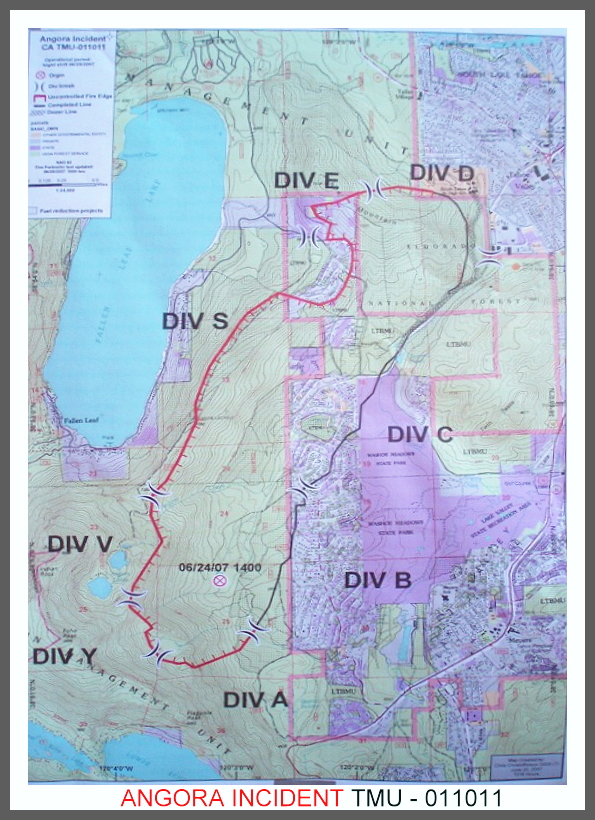
ANGORA FIRE MAP, ANGORA FIRE SOUTH LAKE TAHOE, CALIFORNIA,


No comments:

CNN.com

News: Breaking News -- MercuryNews.com

AP Top U.S. News At 8:45 p.m.