Saturday, August 18, 2007

California Fire News

California Fire News

USFS - Idaho - ICP Burnover - Cascade Complex IC

Posted: 17 Aug 2007 07:47 PM CDT


Central Idaho Fire Update
Cascade ICP Burnover - The Incident Management Team had a "shelter in place" plan for such an event

USFS - Monday, August 13, 2007 at 11:00pm MT

Fire picture taken in Central Idaho.  Picture by Dave GriderToday was another active fire day and several fires continued to threaten structures and communities. Growth on the west side of the Riordan Fire triggered an evacuation order from Governor Otter for a mandatory evacuation of Yellow Pine and Johnson Creek effective at 8:00 a.m., August 14. In order to protect homes and private property along this road and in Yellow Pine, fire tactics may necessitate a burn out operation to remove fuel from the advancing fire front. Preparations for this burn out will begin tomorrow and are expected to take one or two days.

Late today, the North Fork Fire spotted across the South Fork of the Salmon River and burned toward the west and south flanks of the Cascade Complex Incident Command Post and base camp. The Incident Management Team had a "shelter in place" plan for such an event and activated it. Incident Commander, Paul Broyles, said, "We had a good plan, we activated it, and it worked."

Damage to the Incident Command Post and base camp included the loss of one yurt (large tent), 5 firefighter tents and minor damage to one pickup truck. There were no injuries. The rest of the camp facilities are intact. Two historic structures belonging to Knox Ranch, next to the Incident Command Post, were lost. Firefighters were successful in protecting structures around Warm Lake, including the Youth on A Mission Camp, and the Juniper Outfitters facilities and the historic structures at Stolle Meadows.

The Monumental fire continued to grow to the northeast and joined with the Sandy Fire. In addition, there was also some growth on the west side of Stolle Meadows.

Firefighting efforts tomorrow will again focus on structure protection around Warm Lake, Yellowpine, Johnson Creek, Warren and Secesh.

icp burnoverCASCADE-ICP-BURNOVER
CREDIT: UNKNOWN taken from id-bof-cascade-icp-burn-by.pdf

Check out the whole story at: id-bof-cascade-icp-burn-by.pdf

Read a red hot discusssion about this incident event at Wildlandfire.com They said and the Hotlist

Re: ID-BOF-Cascade Complex
ID-BOF-Cascade Complex

209 from 1900 yesterday
Paul Broyles, IC (T1)

Significant events today (closures, evacuations, significant progress made, etc.):
Portions of the Boise, Payette, and Salmon Challis National Forests remain closed. Both the Monumental and North Fork Fires are growing significantly. Yesterday showed a combined fire growth of 27,240. Multiple improvements are threatened at this time. Due to rapid fire growth the number of improvements threatened is undetermined. The southern flank of the North Fork fire is threatening the Cascade Complex ICP. The "Stay in Place Plan" was implemented at Cascade ICP at 16:00 due to this threat. At approximately 1730 a running crown fire enveloped Cascade ICP. A defensive strategy was in place. Some infrastructure and two historical cabins were lost in the Knox Ranch/ICP area. Planning continues to reallocate resources to manage the significant change of both fires.

Remarks:
Yesterday the Monumental and North Fork fire grew a combined 27,240 acres. Today¿s fire growth will most likely mimic the previous operational period.

more info here on the ICP burnover:

Central ID Fire Update http://www.fs.fed.us/idahofires/audi.../indexpm.shtml
(snip)...

Late today, the North Fork Fire spotted across the South Fork of the Salmon River and burned toward the west and south flanks of the Cascade Complex Incident Command Post and base camp. The Incident Management Team had a "shelter in place" plan for such an event and activated it. Incident Commander, Paul Broyles, said, "We had a good plan, we activated it, and it worked."

Damage to the Incident Command Post and base camp included the loss of one yurt (large tent), 5 firefighter tents and minor damage to one pickup truck. There were no injuries. The rest of the camp facilities are intact. Two historic structures belonging to Knox Ranch, next to the Incident Command Post, were lost. Firefighters were successful in protecting structures around Warm Lake, including the Youth on A Mission Camp, and the Juniper Outfitters facilities and the historic structures at Stolle Meadows.

Red flag warning in effect from 1 pm to 9 pm pdt saturday due to gusty winds and low humidity

Posted: 17 Aug 2007 05:42 PM CDT

[EDIS] red flag warning in effect from 1 pm to 9 pm pdt saturday due to gusty winds and low humidity -
SURPRISE VALLEY CALIFORNIA-EASTERN LASSEN COUNTY-WESTERN NEVADA SIERRA FRONT-NORTHERN WASHOE COUNTY-


THE NATIONAL WEATHER SERVICE IN RENO HAS ISSUED A RED FLAG WARNING...WHICH IS IN EFFECT FROM 1 PM TO 9 PM PDT SATURDAY. THE FIRE WEATHER WATCH IS NO LONGER IN EFFECT. LOW PRESSURE OFF THE WASHINGTON COAST WILL PUSH A COLD FRONT TOWARD THE AREA SATURDAY. SOUTHWEST WINDS WILL INCREASE TO 15 TO 25 MPH SATURDAY AFTERNOON ACROSS EXTREME NORTHEAST CALIFORNIA AND WESTERN NEVADA. PEAK WIND GUSTS TO 35 MPH ARE LIKELY BETWEEN 1 AND 9 PM. IN ADDITION... AFTERNOON HUMIDITY WILL DROP TO 5 TO 10 PERCENT CREATING CRITICAL FIRE WEATHER CONDITIONS.

Area: SURPRISE VALLEY CALIFORNIA-EASTERN LASSEN COUNTY-WESTERN NEVADA SIERRA FRONT-NORTHERN WASHOE COUNTY-

Affected Counties or parts of: Modoc, Plumas, Placer, Mono, Lassen, El Dorado, Nevada, Sierra, Alpine,

Sent: 2007-08-17T14:59:03-07:00

Original Sender: KREV@nwws.oes.ca.gov

From: NATIONAL WEATHER SERVICE RENO NV

Local News: Brush Fire Control Water Tower Tapped Into for Pot Plants

Posted: 17 Aug 2007 03:09 PM CDT

abc7.com:
Brush Fire Control Water Tower Tapped Into for Pot Plants
Hillside Plants Discovered On Is Owned by City of Glendale - A sophisticated marijuana operation has been busted in Glendale.

Over 5,000 marijuana plants were discovered. Preliminary estimates put the street value of the pot at $10 million. The hillside where the pot was discovered is owned by the city of Glendale.
A water tower used for brush fire control had been tapped into and was watering pot plants. The tower was half-empty. According to authorities, a chopper checking for brush fires noticed greenery that was out of place and observed suspicious activity. Narcotics officers were notified and they confirmed it was marijuana.
There are no suspects currently in custody and the investigation is ongoing. Multiple agencies are participating in the bust, including the DEA, Glendale Fire, Glendale Public Works, Glendale Park Rangers, Burbank Police, and several L.A. County agencies.

Three great Blogs for more Zaca coverage

Posted: 17 Aug 2007 03:40 PM CDT

Copter ChickAdventures of Copter Chick - This is truly the hottest new blog on the net, Like a Thrilling novel, This beautiful female helicopter pilot is living the storyline in real life with daring high altitude backhauls, Recon on the Zaca, Working Burn Ops, Delivering the news, She is a movie all by herself check it out. (All screen rights reserved)(*WTF?*)
  • Firefighter Blog - Great reading from the keyboard of Firefighter Blog, This firefighting arm chair quarter-back is in full denial but he presents is opinions with a dose of knowledge and sanity, no punches pulled, Willing to say what others only dare to think. Lots of Zaca Maps and pictures and of course comment.

  • Firegeezer.com - Worldwide, National firefighting news and editorials and of course Zaca news and editorial opinion he is the fire geezer after all.

ZACA Fire quick look: 143,212 acres - 59 percent

Posted: 17 Aug 2007 01:29 PM CDT

Zaca Fire Status

Acres Burned: 143,212 acres Percent Contained: 59 percent

Acreage Increase (last 12 hours): 8,816 acres

Fireline to Build: 7 miles

Date Started: July 4, 2007 at 10:53 am

Expected Containment: September 7, 2007

Injuries: 29

Structures Threatened: 595

Structures Destroyed: 1 outbuilding

Resources

Crews: 82

Engines: 226

Helicopters: 23

Air Tankers: 8

Air Attack: 3

Dozers: 57

Water Tenders: 101

Total Personnel Assigned: 2,852

Cost to Date: $76.3 million

Out of State News- Wildfire closes in on Yellowstone resort

Posted: 17 Aug 2007 10:06 AM CDT

Daily Herald - Wildfire closes in on Yellowstone resort:

Wildfire closes in on Yellowstone resort- Firefighters continued to poke at the blaze's edges

PAHASKA TEPEE, Wyo. -- Fire crews shored up defenses around a century-old lodge and houses and cabins outside Yellowstone National Park on Thursday as a 26-square-mile fire continued to push closer through mountainous terrain.

The Columbine Fire, which began with an Aug. 9 lightning strike, was threatening a 1904 lodge built by Buffalo Bill Cody and part of the Pahaska Tepee Resort.

Firefighters continued to poke at the blaze's edges, with three helicopters dumping water buckets and crews attempting to keep the fire from crossing the park's East Entrance Road.

But steep terrain and the potential for wind-driven flare-ups have prevented an all-out attack. Residents and vacationers have already fled in anticipation that it will continue to grow.

At the Buffalo Bill lodge, Byron Bennett, a firefighter from Meeteetse, said he was confident the lodge and surrounding cabins would be saved -- but said everything else could soon go.

"Any embers get in here, we'll snuff them out," Bennett said. "But we might as well get this over with and burn everything else through."

Bennett and others had wrapped a heat-resistant foil around the base of the historic lodge, and set up sprinklers to soak the resort's perimeter. Sprinklers also were set up at around approximately 15 other cabins and lodges along the North Fork of the Shoshone.

From Pahaska, a wide column of smoke backlit by the setting sun filled the western sky. The closest hillsides, while not yet burning, were dotted with thousands of trees killed by a recent beetle infestation. Add in some dry weather and winds gusting up to 20 mph and "that's really prime for fire activity," said Tom Rhode, a U.S. Forest Service fire information officer.

The east entrance to Yellowstone, through which 3,000 or more visitors pass daily during the summer, remained closed. Nevertheless, a steady stream of locals and the occasional tourist drove up to get a look at the massive fire.

"I just wanted to see how far I could get," said Rob Hamilton, who came up from nearby Cody with his wife, Suzi, late Thursday. "All the dead trees up there, they're like a match waiting for something to strike it."

By late Thursday, the fire had moved 2 to 3 miles down Canfield Creek, a drainage near Pahaska, and had spread on its northern and western and flanks, said Jill Cobb, fire information officer.

Cobb said 167 people were fighting the fire in different ways, and more crews were expected. She acknowledged that people and equipment have been slow coming.

"Though this is a high priority, there are a lot of high priorities across the West right now," she said.

Four other fires were burning around Yellowstone but didn't threaten to close any roads or facilities. Two remote fires -- a 1,000-acre fire on the Promontory Peninsula in Yellowstone Lake and a 1,500-acre fire east of the lake -- were not being fought.

A 2,800-acre fire that had been declared fully contained several weeks ago also flared up this week and firefighters were called into prevent the fire from spreading. Also, a 40-acre fire near the park's south entrance was fully contained.

Inciweb: Zaca Wildland Fire - 143,212 acres - 59 percent

Posted: 17 Aug 2007 11:45 AM CDT

Zaca Wildland Fire

Headlines:
There will be an informational meeting on the Zaca Fire on Friday, August 17 at the Halfway House in Ventucopa on Highway 33. The meeting will be at 7 pm.

INCIDENT UPDATED 09:00 hrs

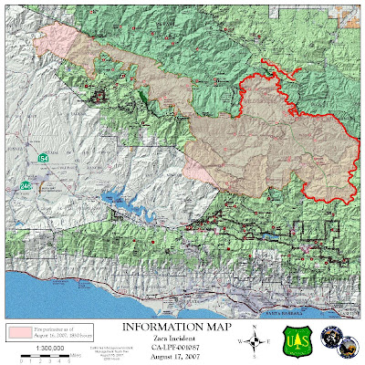
Zaca Fire Perimeter Map
Credit: Zaca Fire GIS/FIO
original map location: link

view pictures || view maps

Summary

Friday, August 17, 2007 6:00 AM

(MORNING UPDATE IN PROGRESS)

Joint Unified Command: Los Padres National Forest and Santa Barbara County Fire Department

On the Web: http://www.sbcfire.com/ or www.fs.fed.us/r5/lospadres or http://www.inciweb.org/

Fire Information Phone Line: (805) 961-5770 (LIVE)

Fire Status

Acres Burned: 143,212 acres

Acreage Increase (last 12 hours): 8,816 acres

Fireline to Build: 7 miles

Date Started: July 4, 2007 at 10:53 am

Percent Contained: 59 percent

Expected Containment: September 7, 2007

Injuries: 29

Structures Threatened: 595

Structures Destroyed: 1 outbuilding

Resources

Crews: 82

Engines: 226

Helicopters: 23

Air Tankers: 8

Air Attack: 3

Dozers: 57

Water Tenders: 101

Total Personnel Assigned: 2,852

Cost to Date: $76.3 million

Headlines

There will be an informational meeting today Friday, August 17, at the Halfway House in Ventucopa on Highway 33. The meeting will start at 7 pm.

Current Situation

(UPDATE IN PROGRESS)

Forest, Road and Area Closures:

  • Happy Canyon Road is closed at Los Padres National Forest boundary.
  • Figueroa Mountain Road is closed at the Los Padres National Forest boundary.
  • East Camino Cielo is closed between Painted Cave Road and Gibraltar Road due to fire equipment traffic.
  • Paradise Road is within the Evacuation Warning Area and is currently open to residents only.
  • The Zaca Fire Area Closure in Los Padres National Forest has been expanded to include additional lands in Santa Barbara, Ventura and Kern Counties. The expanded closure now encompasses approximately 888,000 acres including the entire San Rafael, Matilija and Chumash Wildernesses, a portion of the Sespe Wilderness and adjacent national forest lands. Detailed information on the closure can be found at www.fs.fed.us/r5/lospadres or http://www.inciweb.org/ or your local Forest Service Office.

Evacuations

  • The EVACUATION ORDER for Paradise Road residents, Los Prietos Boys Camp, and the Rancho Oso Guest Ranch has been downgraded to an EVACUATION WARNING.
  • The Santa Ynez River Road campgrounds, day use areas and trailheads remain closed.

Basic Information

Incident Type Wildland Fire
Cause Human Caused
Date of Origin 07/04/2007 at 1053 hrs.
Location 15 miles NE of Buellton
Incident Commander Molumby/ Schmit/ Dietrich

Current Situation

Total Personnel 2,852
Size 143,212 acres
Percent Contained 59%
Estimated Containment Date 09/07/2007 at hrs.
Fuels Involved

Heavy brush containing a high dead component. Some conifer at higher elevations. Live fuel moistures are at 49% which is well below critical levels. A continuous fuel bed lies ahead of the fire.

Fire Behavior

South side of the fire: The fire was very active throughout the night, and made a significant run south down Diablo Canyon, pushed by the north and down canyon winds. North side of the fire: Backing and flanking; uphill runs with extreme fire behavior where drainages align with winds on most portions of the fire. Excellent conditions for burning operations. A large amount of smoke remained on the south east side of the fire.

Significant Events

South side of the fire: The Paradise Road and Santa Ynez River Recreation remain under an evacuation warning, open to residents only. North side of the fire: Major fire runs south of the Sisquoc river on the western perimeter. The fire is well established in Mono Creek three miles west of Three Sisters. Continued burnout operations to the east. Control line established on the north side of the fire. Completed 1.5 burnout on north west side. Formulated firing/attack plan for east and south east side of the fire.

Outlook

Planned Actions

South side of the fire: Patrol, mop-up, and improve existing control lines. Conduct burnout and holding operations along the Ogilvy Ranch Road and Potrero Seco Road. Perform recon, planning and contingency line construction in Branch IX on the east side, and the Santa Barbara front country from Romero Canyon to Lake Casitas. North side of the fire: Monitor and hold burnout operation on the north east and north west side of the fire. Conduct firing operations on the east and south east side of the fire.

Projected Movement

Projections for the fire's activity in the next 12 hours.

South side of the fire: Continued active spread to the east up Mono, Diablo, and Agua Caliente Canyons.

North side of the fire: Northward past Sisquoc River toward Sierra Madre Ridge, Santa Barbara Canyon and Cuyama Peak; south to Mono Creek and Aqua Caliente Canyons.

Growth Potential

Extreme.

Terrain Difficulty

Extreme.

Containment Target

South side of the fire: Indirect line strategy should succeed by 9/7.

North side of the fire: Containment strategy has a moderate chance of succeeding, based on the ability to anchor and hold the fire on Sierra Madre Ridge, toward Hwy 33 and from Highway 33 west, to Three Sisters.

Remarks

South side of the fire: The fire is in Mono Creek, Diablo, and Agua Caliente Canyons. The fire overran the Hildreth Jeepway and became established in Agua Caliente Canyon. Burning operations are being implemented along the contingency lines. Resources are engaging the fire on the east side of the Olgivy burn scar. Percentage of containment and line to build are now being calculated based on the projected control lines. Acreage will continue to reflect actual acres consumed.

north side of the fire: Change in structures at risk is due to a resurvey by the Contingency Group Staff.

Weather

Current Wind Conditions 4 (g-10) mph W
Current Temperature 40 degrees
Current Humidity 40 %

[EDIS] fire weather watch in effect from saturday...

Posted: 17 Aug 2007 09:32 AM CDT

[EDIS] fire weather watch in effect from saturday afternoon through saturday evening for strong winds and low humidity

WESTERN LASSEN-EASTERN PLUMAS-EASTERN SIERRA-EASTERN NEVADA COUNTIES-GREATER LAKE TAHOE AREA-


THE NATIONAL WEATHER SERVICE IN RENO HAS ISSUED A FIRE WEATHER WATCH...WHICH IS IN EFFECT FROM SATURDAY AFTERNOON THROUGH SATURDAY EVENING. LOW PRESSURE OFF THE WASHINGTON COAST WILL PUSH A COLD FRONT TOWARD THE AREA SATURDAY. SOUTHWEST WINDS ARE EXPECTED TO INCREASE TO 10 TO 20 MPH SATURDAY AFTERNOON ACROSS THE NORTHERN SIERRA FROM LASSEN COUNTY SOUTH TO THE LAKE TAHOE BASIN. PEAK WIND GUSTS OF 30 TO 5 MPH ARE POSSIBLE. IN ADDITION... AFTERNOON HUMIDITY WILL DROP TO NEAR 10 PERCENT CREATING THE POTENTIAL FOR CRITICAL FIRE WEATHER CONDTIIONS. WINDS ARE EXPECTED TO DIMINISH DURING THE EVENING HOURS.

Instruction:
A FIRE WEATHER WATCH MEANS THAT CRITICAL FIRE WEATHER CONDITIONS ARE FORECAST TO OCCUR. LISTEN FOR LATER FORECASTS AND POSSIBLE RED FLAG WARNINGS.

Area: WESTERN LASSEN-EASTERN PLUMAS-EASTERN SIERRA-EASTERN NEVADA COUNTIES-GREATER LAKE TAHOE AREA-

Affected Counties or parts of: Modoc, Plumas, Placer, Mono, Lassen, El Dorado, Nevada, Sierra, Alpine,

Sent: 2007-08-17T07:13:16-07:00

No comments:

CNN.com

News: Breaking News -- MercuryNews.com

AP Top U.S. News At 8:45 p.m.